You are here: Home > Network List > TA - USArray Transportable Network (new EarthScope stations) Stations List
> Station M11K Mekoryuk, AK, USA > Earthquake Result Viewer
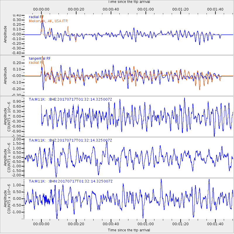
M11K Mekoryuk, AK, USA - Earthquake Result Viewer
*The percent match for this event was below the threshold and hence no stack was calculated.
| Earthquake location: |
Tonga Islands |
| Earthquake latitude/longitude: |
-20.4/-173.3 |
| Earthquake time(UTC): |
2017/07/17 (198) 01:20:32 GMT |
| Earthquake Depth: |
10 km |
| Earthquake Magnitude: |
5.6 Mww |
| Earthquake Catalog/Contributor: |
NEIC PDE/us |
|
| Network: |
TA USArray Transportable Network (new EarthScope stations) |
| Station: |
M11K Mekoryuk, AK, USA |
| Lat/Lon: |
60.38 N/166.20 W |
| Elevation: |
3.0 m |
|
| Distance: |
80.7 deg |
| Az: |
3.577 deg |
| Baz: |
186.767 deg |
| Ray Param: |
$rayparam |
*The percent match for this event was below the threshold and hence was not used in the summary stack. |
|
| Radial Match: |
69.35595 % |
| Radial Bump: |
400 |
| Transverse Match: |
63.91586 % |
| Transverse Bump: |
400 |
| SOD ConfigId: |
13570011 |
| Insert Time: |
2019-04-28 09:43:59.364 +0000 |
| GWidth: |
2.5 |
| Max Bumps: |
400 |
| Tol: |
0.001 |
|
Signal To Noise
| Channel | StoN | STA | LTA |
| TA:M11K: :BHZ:20170717T01:32:14.325007Z | 2.7145286 | 7.415043E-7 | 2.7316136E-7 |
| TA:M11K: :BHN:20170717T01:32:14.325007Z | 0.77578723 | 2.3025149E-7 | 2.9679723E-7 |
| TA:M11K: :BHE:20170717T01:32:14.325007Z | 0.8779121 | 3.096216E-7 | 3.5267954E-7 |
| Arrivals |
| Ps | |
| PpPs | |
| PsPs/PpSs | |


