You are here: Home > Network List > TA - USArray Transportable Network (new EarthScope stations) Stations List
> Station R17K Ugashik Creek, AK, USA > Earthquake Result Viewer
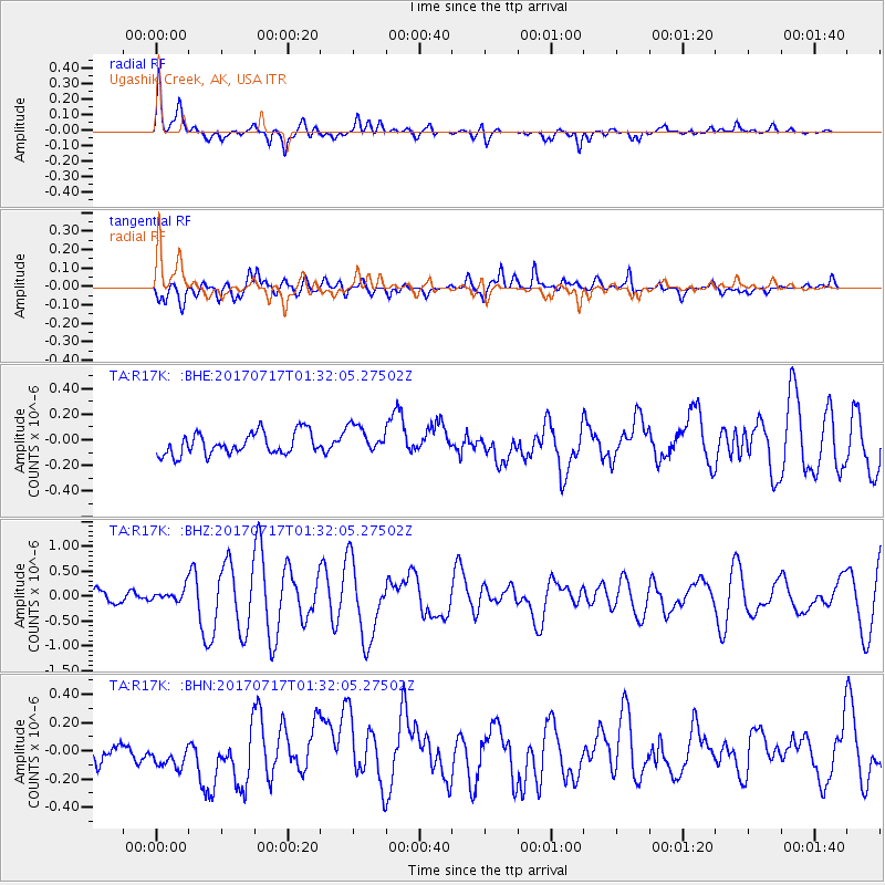
R17K Ugashik Creek, AK, USA - Earthquake Result Viewer
*The percent match for this event was below the threshold and hence no stack was calculated.
| Earthquake location: |
Tonga Islands |
| Earthquake latitude/longitude: |
-20.4/-173.3 |
| Earthquake time(UTC): |
2017/07/17 (198) 01:20:32 GMT |
| Earthquake Depth: |
10 km |
| Earthquake Magnitude: |
5.6 Mww |
| Earthquake Catalog/Contributor: |
NEIC PDE/us |
|
| Network: |
TA USArray Transportable Network (new EarthScope stations) |
| Station: |
R17K Ugashik Creek, AK, USA |
| Lat/Lon: |
57.64 N/156.39 W |
| Elevation: |
273 m |
|
| Distance: |
79.0 deg |
| Az: |
9.182 deg |
| Baz: |
196.161 deg |
| Ray Param: |
$rayparam |
*The percent match for this event was below the threshold and hence was not used in the summary stack. |
|
| Radial Match: |
78.01239 % |
| Radial Bump: |
400 |
| Transverse Match: |
70.01077 % |
| Transverse Bump: |
400 |
| SOD ConfigId: |
13570011 |
| Insert Time: |
2019-04-28 09:44:17.642 +0000 |
| GWidth: |
2.5 |
| Max Bumps: |
400 |
| Tol: |
0.001 |
|
Signal To Noise
| Channel | StoN | STA | LTA |
| TA:R17K: :BHZ:20170717T01:32:05.27502Z | 1.2063286 | 1.4233163E-7 | 1.1798743E-7 |
| TA:R17K: :BHN:20170717T01:32:05.27502Z | 1.7790803 | 1.0320277E-7 | 5.800906E-8 |
| TA:R17K: :BHE:20170717T01:32:05.27502Z | 1.2968392 | 1.1272334E-7 | 8.69216E-8 |
| Arrivals |
| Ps | |
| PpPs | |
| PsPs/PpSs | |


