You are here: Home > Network List > TA - USArray Transportable Network (new EarthScope stations) Stations List
> Station M30A Dale-Ortello Valley, Anselmo, NE, USA > Earthquake Result Viewer
M30A Dale-Ortello Valley, Anselmo, NE, USA - Earthquake Result Viewer
| Earthquake location: |
Southern Peru |
| Earthquake latitude/longitude: |
-15.0/-70.4 |
| Earthquake time(UTC): |
2009/07/12 (193) 06:12:47 GMT |
| Earthquake Depth: |
199 km |
| Earthquake Magnitude: |
5.7 MB, 6.1 MW, 6.1 MW |
| Earthquake Catalog/Contributor: |
WHDF/NEIC |
|
| Network: |
TA USArray Transportable Network (new EarthScope stations) |
| Station: |
M30A Dale-Ortello Valley, Anselmo, NE, USA |
| Lat/Lon: |
41.54 N/99.87 W |
| Elevation: |
853 m |
|
| Distance: |
62.5 deg |
| Az: |
335.434 deg |
| Baz: |
147.652 deg |
| Ray Param: |
0.059561886 |
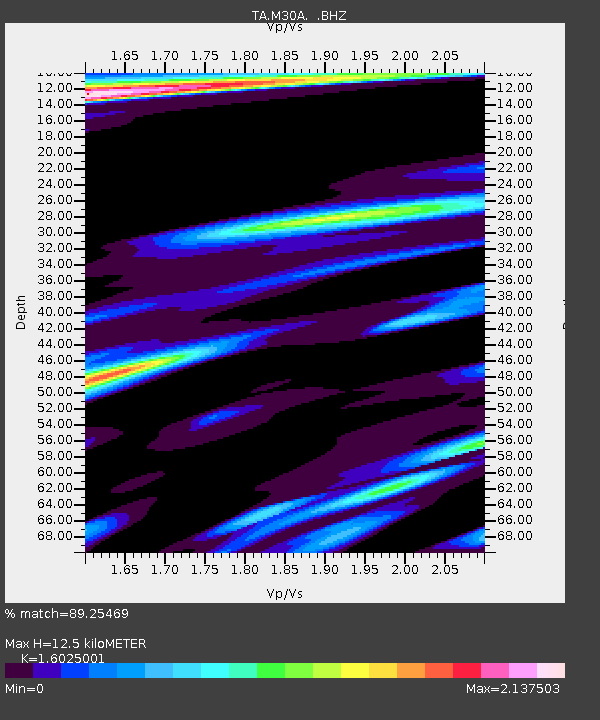
| Estimated Moho Depth: |
12.5 km |
| Estimated Crust Vp/Vs: |
1.60 |
| Assumed Crust Vp: |
6.53 km/s |
| Estimated Crust Vs: |
4.075 km/s |
| Estimated Crust Poisson's Ratio: |
0.18 |
|
| Radial Match: |
89.25469 % |
| Radial Bump: |
400 |
| Transverse Match: |
71.30521 % |
| Transverse Bump: |
400 |
| SOD ConfigId: |
2648 |
| Insert Time: |
2010-03-06 01:55:12.243 +0000 |
| GWidth: |
2.5 |
| Max Bumps: |
400 |
| Tol: |
0.001 |
|

Signal To Noise
| Channel | StoN | STA | LTA |
| TA:M30A: :BHZ:20090712T06:22:18.97502Z | 5.4440618 | 1.7644376E-6 | 3.2410313E-7 |
| TA:M30A: :BHN:20090712T06:22:18.97502Z | 1.4889958 | 8.020077E-7 | 5.386232E-7 |
| TA:M30A: :BHE:20090712T06:22:18.97502Z | 1.4921383 | 8.5273444E-7 | 5.7148486E-7 |
| Arrivals |
| Ps | 1.2 SECOND |
| PpPs | 4.7 SECOND |
| PsPs/PpSs | 6.0 SECOND |


