You are here: Home > Network List > AZ - ANZA Regional Network Stations List
> Station SIO5 Mt. Soledad, La Jolla, CA > Earthquake Result Viewer
SIO5 Mt. Soledad, La Jolla, CA - Earthquake Result Viewer
| Earthquake location: |
Komandorskiye Ostrova Region |
| Earthquake latitude/longitude: |
54.6/168.6 |
| Earthquake time(UTC): |
2017/07/17 (198) 11:05:08 GMT |
| Earthquake Depth: |
7.9 km |
| Earthquake Magnitude: |
6.2 Mww |
| Earthquake Catalog/Contributor: |
NEIC PDE/us |
|
| Network: |
AZ ANZA Regional Network |
| Station: |
SIO5 Mt. Soledad, La Jolla, CA |
| Lat/Lon: |
32.84 N/117.25 W |
| Elevation: |
217 m |
|
| Distance: |
55.0 deg |
| Az: |
81.105 deg |
| Baz: |
316.907 deg |
| Ray Param: |
0.06506628 |
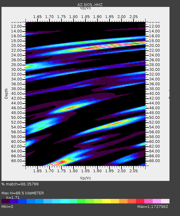
| Estimated Moho Depth: |
69.5 km |
| Estimated Crust Vp/Vs: |
1.71 |
| Assumed Crust Vp: |
6.264 km/s |
| Estimated Crust Vs: |
3.663 km/s |
| Estimated Crust Poisson's Ratio: |
0.24 |
|
| Radial Match: |
88.35799 % |
| Radial Bump: |
400 |
| Transverse Match: |
76.51891 % |
| Transverse Bump: |
400 |
| SOD ConfigId: |
13570011 |
| Insert Time: |
2019-04-28 09:46:28.462 +0000 |
| GWidth: |
2.5 |
| Max Bumps: |
400 |
| Tol: |
0.001 |
|

Signal To Noise
| Channel | StoN | STA | LTA |
| AZ:SIO5: :HHZ:20170717T11:14:09.853025Z | 10.647878 | 1.9643524E-6 | 1.8448299E-7 |
| AZ:SIO5: :HHN:20170717T11:14:09.853025Z | 4.3133235 | 1.1557692E-6 | 2.6795328E-7 |
| AZ:SIO5: :HHE:20170717T11:14:09.853025Z | 2.0373871 | 7.4494665E-7 | 3.6563824E-7 |
| Arrivals |
| Ps | 8.3 SECOND |
| PpPs | 29 SECOND |
| PsPs/PpSs | 37 SECOND |


