You are here: Home > Network List > CC - Cascade Chain Volcano Monitoring Stations List
> Station CIHL Cinder Hill, Newberry, OR > Earthquake Result Viewer
CIHL Cinder Hill, Newberry, OR - Earthquake Result Viewer
| Earthquake location: |
Komandorskiye Ostrova Region |
| Earthquake latitude/longitude: |
54.6/168.6 |
| Earthquake time(UTC): |
2017/07/17 (198) 11:05:08 GMT |
| Earthquake Depth: |
7.9 km |
| Earthquake Magnitude: |
6.2 Mww |
| Earthquake Catalog/Contributor: |
NEIC PDE/us |
|
| Network: |
CC Cascade Chain Volcano Monitoring |
| Station: |
CIHL Cinder Hill, Newberry, OR |
| Lat/Lon: |
43.75 N/121.15 W |
| Elevation: |
1966 m |
|
| Distance: |
45.3 deg |
| Az: |
73.529 deg |
| Baz: |
309.616 deg |
| Ray Param: |
0.071362965 |
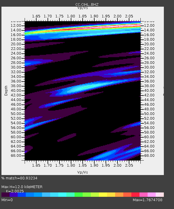
| Estimated Moho Depth: |
12.0 km |
| Estimated Crust Vp/Vs: |
2.00 |
| Assumed Crust Vp: |
6.597 km/s |
| Estimated Crust Vs: |
3.295 km/s |
| Estimated Crust Poisson's Ratio: |
0.33 |
|
| Radial Match: |
80.93234 % |
| Radial Bump: |
400 |
| Transverse Match: |
69.004135 % |
| Transverse Bump: |
400 |
| SOD ConfigId: |
13570011 |
| Insert Time: |
2019-04-28 09:47:01.877 +0000 |
| GWidth: |
2.5 |
| Max Bumps: |
400 |
| Tol: |
0.001 |
|

Signal To Noise
| Channel | StoN | STA | LTA |
| CC:CIHL: :BHZ:20170717T11:12:56.320005Z | 25.560917 | 2.0294367E-6 | 7.939608E-8 |
| CC:CIHL: :BHN:20170717T11:12:56.320005Z | 3.6398692 | 4.91288E-7 | 1.3497407E-7 |
| CC:CIHL: :BHE:20170717T11:12:56.320005Z | 6.747768 | 7.833676E-7 | 1.1609285E-7 |
| Arrivals |
| Ps | 1.9 SECOND |
| PpPs | 5.1 SECOND |
| PsPs/PpSs | 7.1 SECOND |


