You are here: Home > Network List > CI - Caltech Regional Seismic Network Stations List
> Station GRA Grapevine Ranger Station, Death Valley, CA, USA > Earthquake Result Viewer
GRA Grapevine Ranger Station, Death Valley, CA, USA - Earthquake Result Viewer

| Earthquake location: |
Komandorskiye Ostrova Region |
| Earthquake latitude/longitude: |
54.6/168.6 |
| Earthquake time(UTC): |
2017/07/17 (198) 11:05:08 GMT |
| Earthquake Depth: |
7.9 km |
| Earthquake Magnitude: |
6.2 Mww |
| Earthquake Catalog/Contributor: |
NEIC PDE/us |
|
| Network: |
CI Caltech Regional Seismic Network |
| Station: |
GRA Grapevine Ranger Station, Death Valley, CA, USA |
| Lat/Lon: |
37.00 N/117.37 W |
| Elevation: |
689 m |
|
| Distance: |
52.0 deg |
| Az: |
77.598 deg |
| Baz: |
314.754 deg |
| Ray Param: |
0.067052975 |
| Estimated Moho Depth: |
36.5 km |
| Estimated Crust Vp/Vs: |
1.97 |
| Assumed Crust Vp: |
6.279 km/s |
| Estimated Crust Vs: |
3.195 km/s |
| Estimated Crust Poisson's Ratio: |
0.33 |
|
| Radial Match: |
90.578636 % |
| Radial Bump: |
379 |
| Transverse Match: |
83.82454 % |
| Transverse Bump: |
400 |
| SOD ConfigId: |
13570011 |
| Insert Time: |
2019-04-28 09:47:32.098 +0000 |
| GWidth: |
2.5 |
| Max Bumps: |
400 |
| Tol: |
0.001 |
|
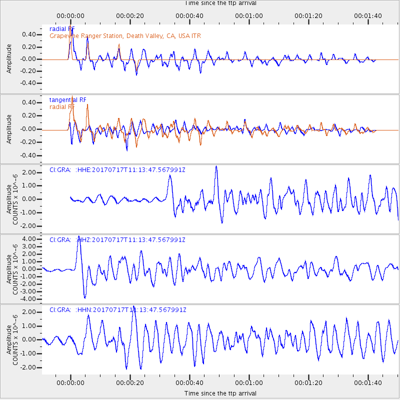
Signal To Noise
| Channel | StoN | STA | LTA |
| CI:GRA: :HHZ:20170717T11:13:47.567991Z | 13.470523 | 2.188546E-6 | 1.6246926E-7 |
| CI:GRA: :HHN:20170717T11:13:47.567991Z | 4.3667574 | 5.897667E-7 | 1.3505827E-7 |
| CI:GRA: :HHE:20170717T11:13:47.567991Z | 4.963655 | 7.977856E-7 | 1.6072543E-7 |
| Arrivals |
| Ps | 5.9 SECOND |
| PpPs | 16 SECOND |
| PsPs/PpSs | 22 SECOND |


