You are here: Home > Network List > CI - Caltech Regional Seismic Network Stations List
> Station MPP McPhearson Peak > Earthquake Result Viewer
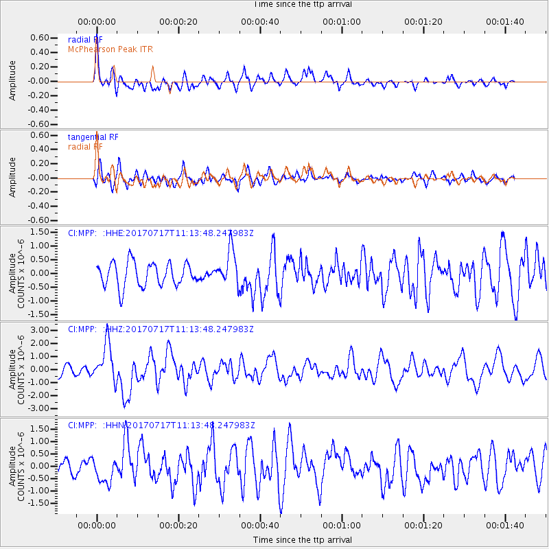
MPP McPhearson Peak - Earthquake Result Viewer
*The percent match for this event was below the threshold and hence no stack was calculated.
| Earthquake location: |
Komandorskiye Ostrova Region |
| Earthquake latitude/longitude: |
54.6/168.6 |
| Earthquake time(UTC): |
2017/07/17 (198) 11:05:08 GMT |
| Earthquake Depth: |
7.9 km |
| Earthquake Magnitude: |
6.2 Mww |
| Earthquake Catalog/Contributor: |
NEIC PDE/us |
|
| Network: |
CI Caltech Regional Seismic Network |
| Station: |
MPP McPhearson Peak |
| Lat/Lon: |
34.89 N/119.81 W |
| Elevation: |
1739 m |
|
| Distance: |
52.1 deg |
| Az: |
81.265 deg |
| Baz: |
315.58 deg |
| Ray Param: |
$rayparam |
*The percent match for this event was below the threshold and hence was not used in the summary stack. |
|
| Radial Match: |
74.49317 % |
| Radial Bump: |
400 |
| Transverse Match: |
65.53782 % |
| Transverse Bump: |
400 |
| SOD ConfigId: |
13570011 |
| Insert Time: |
2019-04-28 09:47:41.044 +0000 |
| GWidth: |
2.5 |
| Max Bumps: |
400 |
| Tol: |
0.001 |
|
Signal To Noise
| Channel | StoN | STA | LTA |
| CI:MPP: :HHZ:20170717T11:13:48.247983Z | 3.847376 | 1.5268548E-6 | 3.9685614E-7 |
| CI:MPP: :HHN:20170717T11:13:48.247983Z | 2.1392555 | 5.101289E-7 | 2.3846096E-7 |
| CI:MPP: :HHE:20170717T11:13:48.247983Z | 1.5577368 | 6.6973297E-7 | 4.2993977E-7 |
| Arrivals |
| Ps | |
| PpPs | |
| PsPs/PpSs | |


