You are here: Home > Network List > CN - Canadian National Seismograph Network Stations List
> Station A16 Riviere Ouelle, QC, CA > Earthquake Result Viewer
A16 Riviere Ouelle, QC, CA - Earthquake Result Viewer
| Earthquake location: |
Komandorskiye Ostrova Region |
| Earthquake latitude/longitude: |
54.6/168.6 |
| Earthquake time(UTC): |
2017/07/17 (198) 11:05:08 GMT |
| Earthquake Depth: |
7.9 km |
| Earthquake Magnitude: |
6.2 Mww |
| Earthquake Catalog/Contributor: |
NEIC PDE/us |
|
| Network: |
CN Canadian National Seismograph Network |
| Station: |
A16 Riviere Ouelle, QC, CA |
| Lat/Lon: |
47.47 N/70.01 W |
| Elevation: |
13 m |
|
| Distance: |
66.9 deg |
| Az: |
39.038 deg |
| Baz: |
327.289 deg |
| Ray Param: |
0.05729492 |
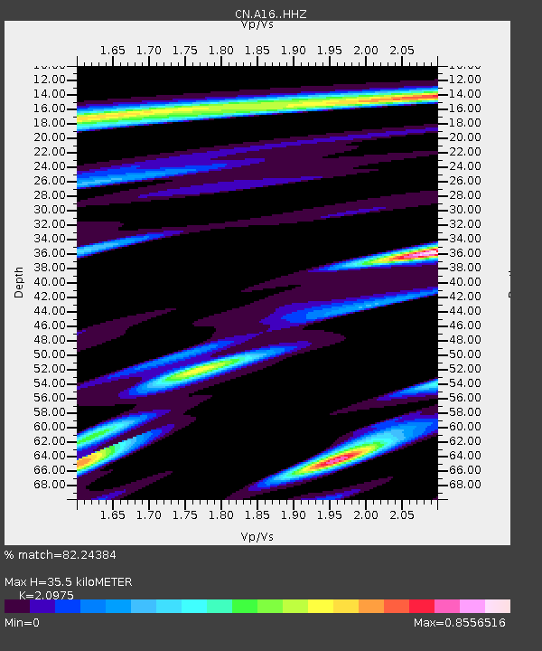
| Estimated Moho Depth: |
35.5 km |
| Estimated Crust Vp/Vs: |
2.10 |
| Assumed Crust Vp: |
6.61 km/s |
| Estimated Crust Vs: |
3.151 km/s |
| Estimated Crust Poisson's Ratio: |
0.35 |
|
| Radial Match: |
82.24384 % |
| Radial Bump: |
382 |
| Transverse Match: |
47.660774 % |
| Transverse Bump: |
400 |
| SOD ConfigId: |
13570011 |
| Insert Time: |
2019-04-28 09:48:06.127 +0000 |
| GWidth: |
2.5 |
| Max Bumps: |
400 |
| Tol: |
0.001 |
|

Signal To Noise
| Channel | StoN | STA | LTA |
| CN:A16: :HHZ:20170717T11:15:30.499998Z | 3.8473547 | 3.6408542E-7 | 9.463267E-8 |
| CN:A16: :HHN:20170717T11:15:30.499998Z | 2.0111682 | 1.4168042E-7 | 7.0446816E-8 |
| CN:A16: :HHE:20170717T11:15:30.499998Z | 1.1218896 | 1.322475E-7 | 1.1787923E-7 |
| Arrivals |
| Ps | 6.1 SECOND |
| PpPs | 16 SECOND |
| PsPs/PpSs | 22 SECOND |


