You are here: Home > Network List > TA - USArray Transportable Network (new EarthScope stations) Stations List
> Station N29A Votaw Ranch, Wellfleet, NE, USA > Earthquake Result Viewer
N29A Votaw Ranch, Wellfleet, NE, USA - Earthquake Result Viewer
| Earthquake location: |
Fox Islands, Aleutian Islands |
| Earthquake latitude/longitude: |
52.8/-167.0 |
| Earthquake time(UTC): |
2009/10/13 (286) 05:37:23 GMT |
| Earthquake Depth: |
24 km |
| Earthquake Magnitude: |
6.0 MB, 6.1 MS, 6.5 MW, 6.5 MW |
| Earthquake Catalog/Contributor: |
WHDF/NEIC |
|
| Network: |
TA USArray Transportable Network (new EarthScope stations) |
| Station: |
N29A Votaw Ranch, Wellfleet, NE, USA |
| Lat/Lon: |
40.82 N/100.63 W |
| Elevation: |
897 m |
|
| Distance: |
45.4 deg |
| Az: |
77.494 deg |
| Baz: |
308.568 deg |
| Ray Param: |
0.07125363 |
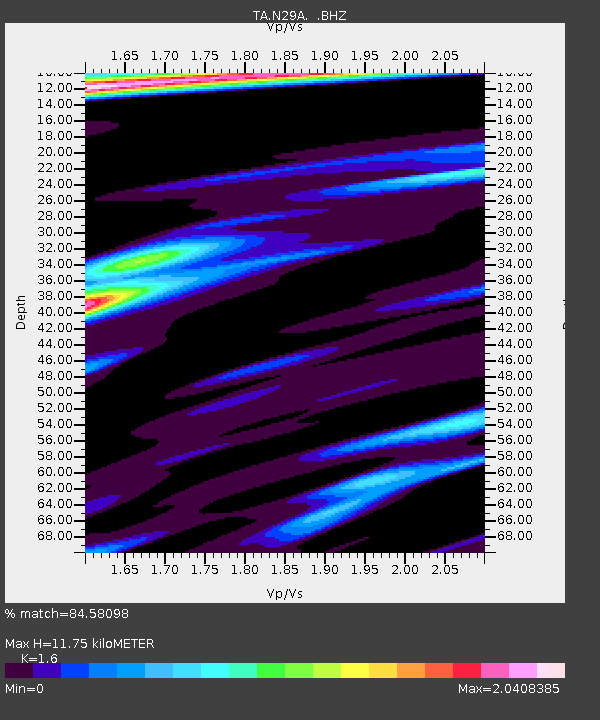
| Estimated Moho Depth: |
11.75 km |
| Estimated Crust Vp/Vs: |
1.60 |
| Assumed Crust Vp: |
6.483 km/s |
| Estimated Crust Vs: |
4.052 km/s |
| Estimated Crust Poisson's Ratio: |
0.18 |
|
| Radial Match: |
84.58098 % |
| Radial Bump: |
336 |
| Transverse Match: |
66.93384 % |
| Transverse Bump: |
341 |
| SOD ConfigId: |
2622 |
| Insert Time: |
2010-03-06 01:55:58.072 +0000 |
| GWidth: |
2.5 |
| Max Bumps: |
400 |
| Tol: |
0.001 |
|
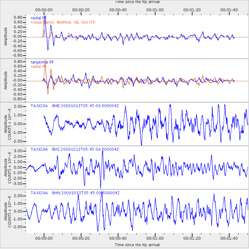
Signal To Noise
| Channel | StoN | STA | LTA |
| TA:N29A: :BHZ:20091013T05:45:09.600004Z | 2.5415347 | 5.4920037E-7 | 2.1609006E-7 |
| TA:N29A: :BHN:20091013T05:45:09.600004Z | 1.0321242 | 4.4271877E-7 | 4.2893944E-7 |
| TA:N29A: :BHE:20091013T05:45:09.600004Z | 0.7564539 | 3.5749568E-7 | 4.7259414E-7 |
| Arrivals |
| Ps | 1.2 SECOND |
| PpPs | 4.4 SECOND |
| PsPs/PpSs | 5.6 SECOND |


