You are here: Home > Network List > TA - USArray Transportable Network (new EarthScope stations) Stations List
> Station N29A Votaw Ranch, Wellfleet, NE, USA > Earthquake Result Viewer
N29A Votaw Ranch, Wellfleet, NE, USA - Earthquake Result Viewer
| Earthquake location: |
Hokkaido, Japan Region |
| Earthquake latitude/longitude: |
41.8/143.4 |
| Earthquake time(UTC): |
2009/06/05 (156) 03:30:33 GMT |
| Earthquake Depth: |
29 km |
| Earthquake Magnitude: |
6.0 MB, 6.3 MS, 6.4 MW, 6.4 MW |
| Earthquake Catalog/Contributor: |
WHDF/NEIC |
|
| Network: |
TA USArray Transportable Network (new EarthScope stations) |
| Station: |
N29A Votaw Ranch, Wellfleet, NE, USA |
| Lat/Lon: |
40.82 N/100.63 W |
| Elevation: |
897 m |
|
| Distance: |
79.4 deg |
| Az: |
43.986 deg |
| Baz: |
316.848 deg |
| Ray Param: |
0.048974313 |
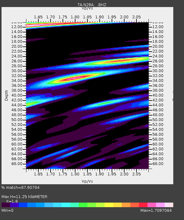
| Estimated Moho Depth: |
11.25 km |
| Estimated Crust Vp/Vs: |
1.60 |
| Assumed Crust Vp: |
6.483 km/s |
| Estimated Crust Vs: |
4.052 km/s |
| Estimated Crust Poisson's Ratio: |
0.18 |
|
| Radial Match: |
87.90784 % |
| Radial Bump: |
400 |
| Transverse Match: |
77.929695 % |
| Transverse Bump: |
400 |
| SOD ConfigId: |
2648 |
| Insert Time: |
2010-03-06 01:56:01.791 +0000 |
| GWidth: |
2.5 |
| Max Bumps: |
400 |
| Tol: |
0.001 |
|

Signal To Noise
| Channel | StoN | STA | LTA |
| TA:N29A: :BHZ:20090605T03:42:05.000002Z | 10.1135235 | 1.0126829E-6 | 1.0013157E-7 |
| TA:N29A: :BHN:20090605T03:42:05.000002Z | 2.5253928 | 3.681457E-7 | 1.4577759E-7 |
| TA:N29A: :BHE:20090605T03:42:05.000002Z | 2.5918913 | 3.706659E-7 | 1.4300983E-7 |
| Arrivals |
| Ps | 1.1 SECOND |
| PpPs | 4.4 SECOND |
| PsPs/PpSs | 5.4 SECOND |


