You are here: Home > Network List > CN - Canadian National Seismograph Network Stations List
> Station GTOO Geraldton, ON, CA > Earthquake Result Viewer
GTOO Geraldton, ON, CA - Earthquake Result Viewer
| Earthquake location: |
Komandorskiye Ostrova Region |
| Earthquake latitude/longitude: |
54.6/168.6 |
| Earthquake time(UTC): |
2017/07/17 (198) 11:05:08 GMT |
| Earthquake Depth: |
7.9 km |
| Earthquake Magnitude: |
6.2 Mww |
| Earthquake Catalog/Contributor: |
NEIC PDE/us |
|
| Network: |
CN Canadian National Seismograph Network |
| Station: |
GTOO Geraldton, ON, CA |
| Lat/Lon: |
49.75 N/86.96 W |
| Elevation: |
359 m |
|
| Distance: |
58.3 deg |
| Az: |
47.583 deg |
| Baz: |
318.511 deg |
| Ray Param: |
0.06291554 |
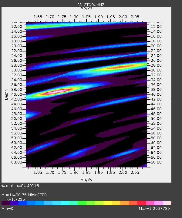
| Estimated Moho Depth: |
38.75 km |
| Estimated Crust Vp/Vs: |
1.72 |
| Assumed Crust Vp: |
6.472 km/s |
| Estimated Crust Vs: |
3.757 km/s |
| Estimated Crust Poisson's Ratio: |
0.25 |
|
| Radial Match: |
84.40115 % |
| Radial Bump: |
400 |
| Transverse Match: |
73.20377 % |
| Transverse Bump: |
400 |
| SOD ConfigId: |
13570011 |
| Insert Time: |
2019-04-28 09:48:29.424 +0000 |
| GWidth: |
2.5 |
| Max Bumps: |
400 |
| Tol: |
0.001 |
|

Signal To Noise
| Channel | StoN | STA | LTA |
| CN:GTOO: :HHZ:20170717T11:14:33.270017Z | 5.001171 | 4.351657E-7 | 8.701276E-8 |
| CN:GTOO: :HHN:20170717T11:14:33.270017Z | 2.193017 | 1.518303E-7 | 6.923353E-8 |
| CN:GTOO: :HHE:20170717T11:14:33.270017Z | 2.8141844 | 1.2385253E-7 | 4.40101E-8 |
| Arrivals |
| Ps | 4.6 SECOND |
| PpPs | 15 SECOND |
| PsPs/PpSs | 20 SECOND |


