You are here: Home > Network List > GO - National Seismic Network of Georgia Stations List
> Station AKH Akhalkalaki > Earthquake Result Viewer
AKH Akhalkalaki - Earthquake Result Viewer
| Earthquake location: |
Komandorskiye Ostrova Region |
| Earthquake latitude/longitude: |
54.6/168.6 |
| Earthquake time(UTC): |
2017/07/17 (198) 11:05:08 GMT |
| Earthquake Depth: |
7.9 km |
| Earthquake Magnitude: |
6.2 Mww |
| Earthquake Catalog/Contributor: |
NEIC PDE/us |
|
| Network: |
GO National Seismic Network of Georgia |
| Station: |
AKH Akhalkalaki |
| Lat/Lon: |
41.41 N/43.49 E |
| Elevation: |
1720 m |
|
| Distance: |
73.5 deg |
| Az: |
320.108 deg |
| Baz: |
29.758 deg |
| Ray Param: |
0.052952778 |
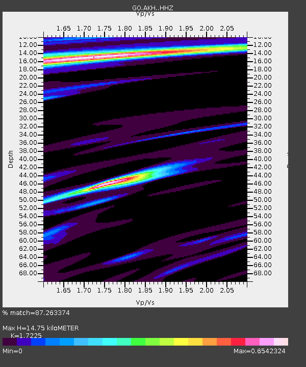
| Estimated Moho Depth: |
14.75 km |
| Estimated Crust Vp/Vs: |
1.72 |
| Assumed Crust Vp: |
6.419 km/s |
| Estimated Crust Vs: |
3.727 km/s |
| Estimated Crust Poisson's Ratio: |
0.25 |
|
| Radial Match: |
87.263374 % |
| Radial Bump: |
400 |
| Transverse Match: |
80.311615 % |
| Transverse Bump: |
400 |
| SOD ConfigId: |
13570011 |
| Insert Time: |
2019-04-28 09:49:56.405 +0000 |
| GWidth: |
2.5 |
| Max Bumps: |
400 |
| Tol: |
0.001 |
|

Signal To Noise
| Channel | StoN | STA | LTA |
| GO:AKH: :HHZ:20170717T11:16:10.770017Z | 13.439394 | 2.0476105E-6 | 1.5235884E-7 |
| GO:AKH: :HHN:20170717T11:16:10.770017Z | 2.4339736 | 8.492528E-7 | 3.489162E-7 |
| GO:AKH: :HHE:20170717T11:16:10.770017Z | 1.7038872 | 4.2320272E-7 | 2.4837485E-7 |
| Arrivals |
| Ps | 1.7 SECOND |
| PpPs | 6.0 SECOND |
| PsPs/PpSs | 7.8 SECOND |


