You are here: Home > Network List > JP - Japan Meteorological Agency Seismic Network Stations List
> Station JCJ Chichijima Island > Earthquake Result Viewer
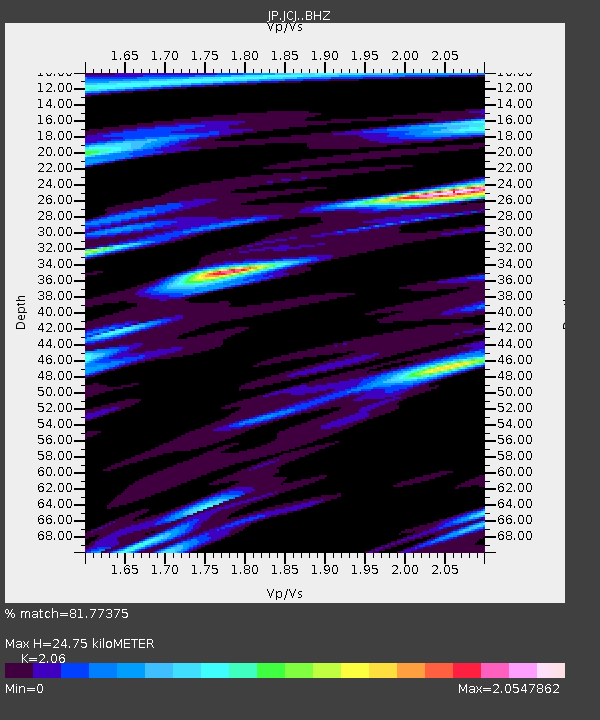
JCJ Chichijima Island - Earthquake Result Viewer
| Earthquake location: |
Komandorskiye Ostrova Region |
| Earthquake latitude/longitude: |
54.6/168.6 |
| Earthquake time(UTC): |
2017/07/17 (198) 11:05:08 GMT |
| Earthquake Depth: |
7.9 km |
| Earthquake Magnitude: |
6.2 Mww |
| Earthquake Catalog/Contributor: |
NEIC PDE/us |
|
| Network: |
JP Japan Meteorological Agency Seismic Network |
| Station: |
JCJ Chichijima Island |
| Lat/Lon: |
27.10 N/142.18 E |
| Elevation: |
150 m |
|
| Distance: |
33.6 deg |
| Az: |
225.885 deg |
| Baz: |
27.957 deg |
| Ray Param: |
0.078139275 |
| Estimated Moho Depth: |
24.75 km |
| Estimated Crust Vp/Vs: |
2.06 |
| Assumed Crust Vp: |
4.24 km/s |
| Estimated Crust Vs: |
2.058 km/s |
| Estimated Crust Poisson's Ratio: |
0.35 |
|
| Radial Match: |
81.77375 % |
| Radial Bump: |
400 |
| Transverse Match: |
70.2476 % |
| Transverse Bump: |
400 |
| SOD ConfigId: |
13570011 |
| Insert Time: |
2019-04-28 09:50:38.234 +0000 |
| GWidth: |
2.5 |
| Max Bumps: |
400 |
| Tol: |
0.001 |
|

Signal To Noise
| Channel | StoN | STA | LTA |
| JP:JCJ: :BHZ:20170717T11:11:18.799985Z | 3.2275617 | 7.5889443E-7 | 2.3512932E-7 |
| JP:JCJ: :BHN:20170717T11:11:18.799985Z | 2.5901046 | 5.709184E-7 | 2.2042292E-7 |
| JP:JCJ: :BHE:20170717T11:11:18.799985Z | 1.2287798 | 2.4265617E-7 | 1.9747733E-7 |
| Arrivals |
| Ps | 6.4 SECOND |
| PpPs | 17 SECOND |
| PsPs/PpSs | 24 SECOND |


