You are here: Home > Network List > LD - Lamont-Doherty Cooperative Seismographic Network Stations List
> Station GEDE Greenville, DE, USA > Earthquake Result Viewer
GEDE Greenville, DE, USA - Earthquake Result Viewer

| Earthquake location: |
Komandorskiye Ostrova Region |
| Earthquake latitude/longitude: |
54.6/168.6 |
| Earthquake time(UTC): |
2017/07/17 (198) 11:05:08 GMT |
| Earthquake Depth: |
7.9 km |
| Earthquake Magnitude: |
6.2 Mww |
| Earthquake Catalog/Contributor: |
NEIC PDE/us |
|
| Network: |
LD Lamont-Doherty Cooperative Seismographic Network |
| Station: |
GEDE Greenville, DE, USA |
| Lat/Lon: |
39.81 N/75.64 W |
| Elevation: |
105 m |
|
| Distance: |
71.1 deg |
| Az: |
47.183 deg |
| Baz: |
326.333 deg |
| Ray Param: |
0.054549873 |
| Estimated Moho Depth: |
16.75 km |
| Estimated Crust Vp/Vs: |
1.60 |
| Assumed Crust Vp: |
6.287 km/s |
| Estimated Crust Vs: |
3.93 km/s |
| Estimated Crust Poisson's Ratio: |
0.18 |
|
| Radial Match: |
83.6669 % |
| Radial Bump: |
400 |
| Transverse Match: |
67.46145 % |
| Transverse Bump: |
400 |
| SOD ConfigId: |
13570011 |
| Insert Time: |
2019-04-28 09:51:11.556 +0000 |
| GWidth: |
2.5 |
| Max Bumps: |
400 |
| Tol: |
0.001 |
|
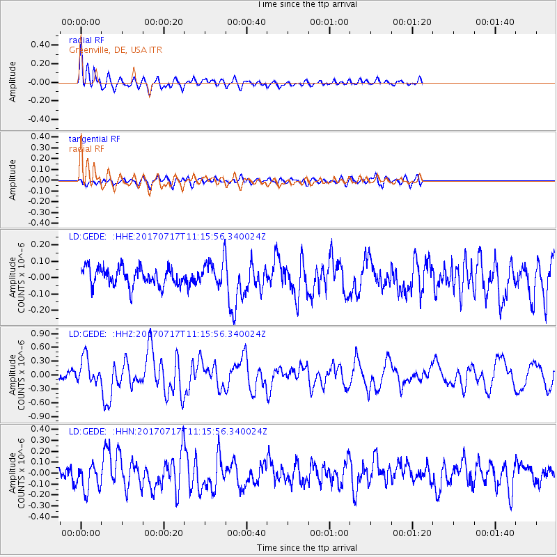
Signal To Noise
| Channel | StoN | STA | LTA |
| LD:GEDE: :HHZ:20170717T11:15:56.340024Z | 3.8001583 | 2.9256827E-7 | 7.698844E-8 |
| LD:GEDE: :HHN:20170717T11:15:56.340024Z | 1.7188971 | 1.1936906E-7 | 6.944515E-8 |
| LD:GEDE: :HHE:20170717T11:15:56.340024Z | 1.5722305 | 8.7769855E-8 | 5.5825055E-8 |
| Arrivals |
| Ps | 1.7 SECOND |
| PpPs | 6.7 SECOND |
| PsPs/PpSs | 8.3 SECOND |


