You are here: Home > Network List > GS - US Geological Survey Networks Stations List
> Station KAN08 Pence Farm, Harper, KS, USA > Earthquake Result Viewer
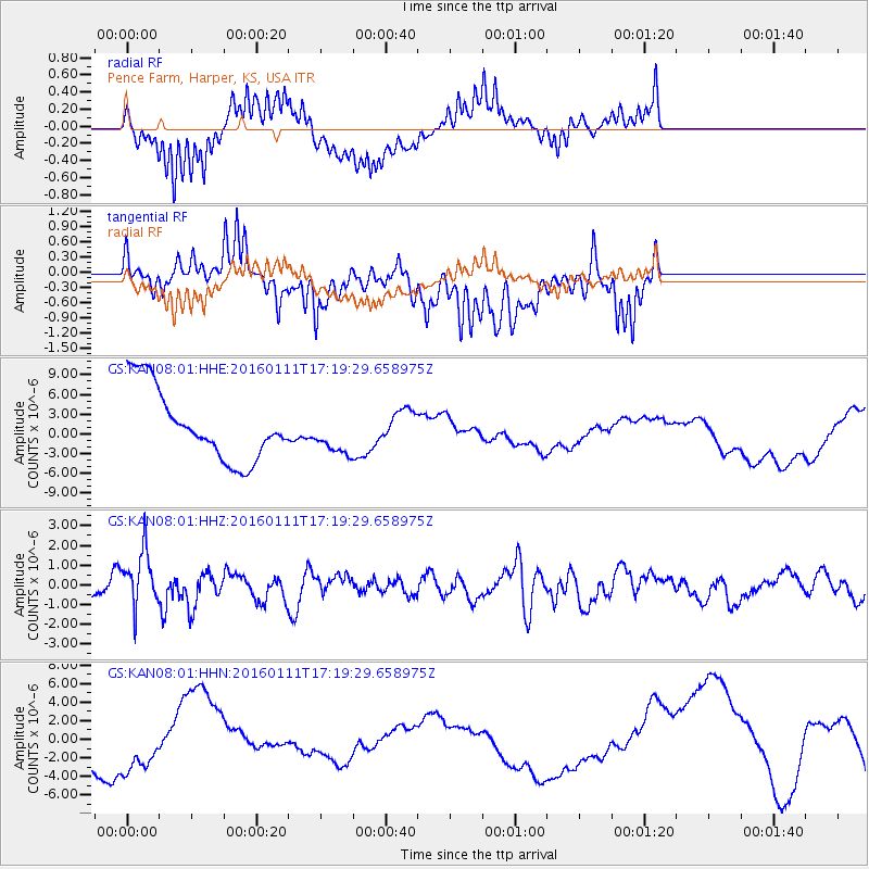
KAN08 Pence Farm, Harper, KS, USA - Earthquake Result Viewer
*The percent match for this event was below the threshold and hence no stack was calculated.
| Earthquake location: |
Hokkaido, Japan Region |
| Earthquake latitude/longitude: |
44.5/141.1 |
| Earthquake time(UTC): |
2016/01/11 (011) 17:08:03 GMT |
| Earthquake Depth: |
240 km |
| Earthquake Magnitude: |
6.2 MWW |
| Earthquake Catalog/Contributor: |
NEIC PDE/NEIC COMCAT |
|
| Network: |
GS US Geological Survey Networks |
| Station: |
KAN08 Pence Farm, Harper, KS, USA |
| Lat/Lon: |
37.23 N/97.97 W |
| Elevation: |
375 m |
|
| Distance: |
82.7 deg |
| Az: |
43.636 deg |
| Baz: |
321.754 deg |
| Ray Param: |
$rayparam |
*The percent match for this event was below the threshold and hence was not used in the summary stack. |
|
| Radial Match: |
67.20521 % |
| Radial Bump: |
400 |
| Transverse Match: |
18.202394 % |
| Transverse Bump: |
400 |
| SOD ConfigId: |
1399611 |
| Insert Time: |
2016-01-25 17:35:43.613 +0000 |
| GWidth: |
2.5 |
| Max Bumps: |
400 |
| Tol: |
0.001 |
|
Signal To Noise
| Channel | StoN | STA | LTA |
| GS:KAN08:01:HHZ:20160111T17:19:29.658975Z | 2.2525492 | 1.429438E-6 | 6.345868E-7 |
| GS:KAN08:01:HHN:20160111T17:19:29.658975Z | 1.1553272 | 4.521991E-6 | 3.9140346E-6 |
| GS:KAN08:01:HHE:20160111T17:19:29.658975Z | 0.6021837 | 3.2478856E-6 | 5.393513E-6 |
| Arrivals |
| Ps | |
| PpPs | |
| PsPs/PpSs | |


