You are here: Home > Network List > TA - USArray Transportable Network (new EarthScope stations) Stations List
> Station N28A Pribbeno Ranch, Imperial, NE, USA > Earthquake Result Viewer
N28A Pribbeno Ranch, Imperial, NE, USA - Earthquake Result Viewer
| Earthquake location: |
Samoa Islands Region |
| Earthquake latitude/longitude: |
-15.5/-172.1 |
| Earthquake time(UTC): |
2009/09/29 (272) 17:48:10 GMT |
| Earthquake Depth: |
18 km |
| Earthquake Magnitude: |
7.1 MB, 8.1 MS, 8.1 MW, 8.0 MW |
| Earthquake Catalog/Contributor: |
WHDF/NEIC |
|
| Network: |
TA USArray Transportable Network (new EarthScope stations) |
| Station: |
N28A Pribbeno Ranch, Imperial, NE, USA |
| Lat/Lon: |
40.69 N/101.54 W |
| Elevation: |
1009 m |
|
| Distance: |
85.9 deg |
| Az: |
45.965 deg |
| Baz: |
245.712 deg |
| Ray Param: |
0.044429615 |
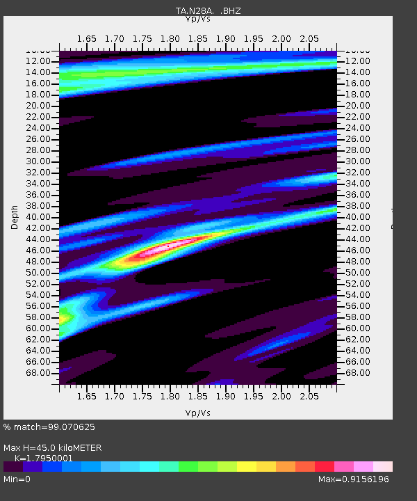
| Estimated Moho Depth: |
45.0 km |
| Estimated Crust Vp/Vs: |
1.80 |
| Assumed Crust Vp: |
6.483 km/s |
| Estimated Crust Vs: |
3.611 km/s |
| Estimated Crust Poisson's Ratio: |
0.27 |
|
| Radial Match: |
99.070625 % |
| Radial Bump: |
322 |
| Transverse Match: |
88.63186 % |
| Transverse Bump: |
400 |
| SOD ConfigId: |
2622 |
| Insert Time: |
2010-03-06 01:56:37.132 +0000 |
| GWidth: |
2.5 |
| Max Bumps: |
400 |
| Tol: |
0.001 |
|
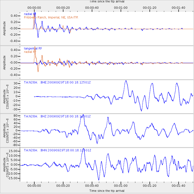
Signal To Noise
| Channel | StoN | STA | LTA |
| TA:N28A: :BHZ:20090929T18:00:18.12501Z | 9.607864 | 2.8584832E-6 | 2.9751493E-7 |
| TA:N28A: :BHN:20090929T18:00:18.12501Z | 1.0443283 | 4.2810555E-7 | 4.0993385E-7 |
| TA:N28A: :BHE:20090929T18:00:18.12501Z | 3.7285872 | 1.274878E-6 | 3.4191984E-7 |
| Arrivals |
| Ps | 5.7 SECOND |
| PpPs | 19 SECOND |
| PsPs/PpSs | 25 SECOND |


