You are here: Home > Network List > IU - Global Seismograph Network (GSN - IRIS/USGS) Stations List
> Station CTAO Charters Towers, Australia > Earthquake Result Viewer
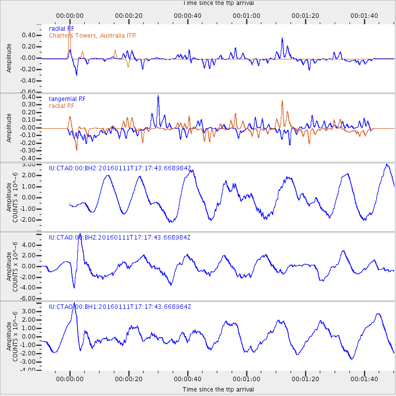
CTAO Charters Towers, Australia - Earthquake Result Viewer
*The percent match for this event was below the threshold and hence no stack was calculated.
| Earthquake location: |
Hokkaido, Japan Region |
| Earthquake latitude/longitude: |
44.5/141.1 |
| Earthquake time(UTC): |
2016/01/11 (011) 17:08:03 GMT |
| Earthquake Depth: |
240 km |
| Earthquake Magnitude: |
6.2 MWW |
| Earthquake Catalog/Contributor: |
NEIC PDE/NEIC COMCAT |
|
| Network: |
IU Global Seismograph Network (GSN - IRIS/USGS) |
| Station: |
CTAO Charters Towers, Australia |
| Lat/Lon: |
20.09 S/146.25 E |
| Elevation: |
357 m |
|
| Distance: |
64.4 deg |
| Az: |
174.603 deg |
| Baz: |
355.891 deg |
| Ray Param: |
$rayparam |
*The percent match for this event was below the threshold and hence was not used in the summary stack. |
|
| Radial Match: |
66.36871 % |
| Radial Bump: |
277 |
| Transverse Match: |
53.786823 % |
| Transverse Bump: |
400 |
| SOD ConfigId: |
1399611 |
| Insert Time: |
2016-01-25 17:38:10.070 +0000 |
| GWidth: |
2.5 |
| Max Bumps: |
400 |
| Tol: |
0.001 |
|
Signal To Noise
| Channel | StoN | STA | LTA |
| IU:CTAO:00:BHZ:20160111T17:17:43.668984Z | 1.9268309 | 3.251871E-6 | 1.6876785E-6 |
| IU:CTAO:00:BH1:20160111T17:17:43.668984Z | 2.2937026 | 2.2484528E-6 | 9.802721E-7 |
| IU:CTAO:00:BH2:20160111T17:17:43.668984Z | 1.3016914 | 1.4403284E-6 | 1.1065054E-6 |
| Arrivals |
| Ps | |
| PpPs | |
| PsPs/PpSs | |


