You are here: Home > Network List > TA - USArray Transportable Network (new EarthScope stations) Stations List
> Station N30A Hueftle Ranch, Cozad, NE, USA > Earthquake Result Viewer
N30A Hueftle Ranch, Cozad, NE, USA - Earthquake Result Viewer
| Earthquake location: |
Southeast Of Honshu, Japan |
| Earthquake latitude/longitude: |
32.8/140.4 |
| Earthquake time(UTC): |
2009/08/12 (224) 22:48:51 GMT |
| Earthquake Depth: |
53 km |
| Earthquake Magnitude: |
6.2 MB, 6.6 MW, 6.6 MW |
| Earthquake Catalog/Contributor: |
WHDF/NEIC |
|
| Network: |
TA USArray Transportable Network (new EarthScope stations) |
| Station: |
N30A Hueftle Ranch, Cozad, NE, USA |
| Lat/Lon: |
40.80 N/100.10 W |
| Elevation: |
842 m |
|
| Distance: |
87.9 deg |
| Az: |
41.39 deg |
| Baz: |
312.836 deg |
| Ray Param: |
0.042878598 |
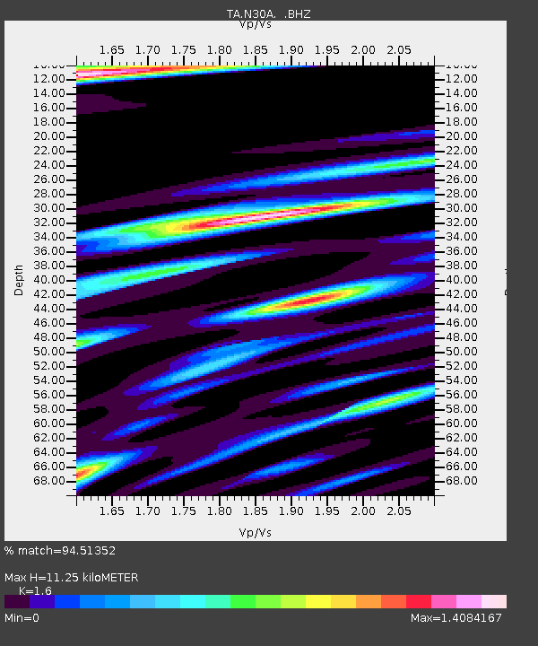
| Estimated Moho Depth: |
11.25 km |
| Estimated Crust Vp/Vs: |
1.60 |
| Assumed Crust Vp: |
6.483 km/s |
| Estimated Crust Vs: |
4.052 km/s |
| Estimated Crust Poisson's Ratio: |
0.18 |
|
| Radial Match: |
94.51352 % |
| Radial Bump: |
385 |
| Transverse Match: |
85.04266 % |
| Transverse Bump: |
400 |
| SOD ConfigId: |
2622 |
| Insert Time: |
2010-03-06 01:57:40.051 +0000 |
| GWidth: |
2.5 |
| Max Bumps: |
400 |
| Tol: |
0.001 |
|
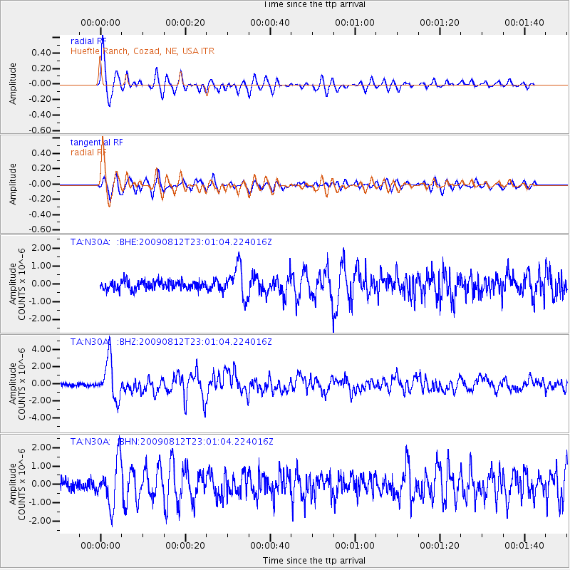
Signal To Noise
| Channel | StoN | STA | LTA |
| TA:N30A: :BHZ:20090812T23:01:04.224016Z | 16.196451 | 2.340005E-6 | 1.4447642E-7 |
| TA:N30A: :BHN:20090812T23:01:04.224016Z | 5.887701 | 1.2471264E-6 | 2.1181891E-7 |
| TA:N30A: :BHE:20090812T23:01:04.224016Z | 3.869986 | 8.8324555E-7 | 2.2822965E-7 |
| Arrivals |
| Ps | 1.1 SECOND |
| PpPs | 4.4 SECOND |
| PsPs/PpSs | 5.5 SECOND |


