You are here: Home > Network List > TA - USArray Transportable Network (new EarthScope stations) Stations List
> Station N30A Hueftle Ranch, Cozad, NE, USA > Earthquake Result Viewer
N30A Hueftle Ranch, Cozad, NE, USA - Earthquake Result Viewer
| Earthquake location: |
Near Coast Of Venezuela |
| Earthquake latitude/longitude: |
10.7/-67.9 |
| Earthquake time(UTC): |
2009/09/12 (255) 20:06:24 GMT |
| Earthquake Depth: |
10 km |
| Earthquake Magnitude: |
6.3 MB, 6.4 MS, 6.3 MW, 6.3 MW |
| Earthquake Catalog/Contributor: |
WHDF/NEIC |
|
| Network: |
TA USArray Transportable Network (new EarthScope stations) |
| Station: |
N30A Hueftle Ranch, Cozad, NE, USA |
| Lat/Lon: |
40.80 N/100.10 W |
| Elevation: |
842 m |
|
| Distance: |
41.3 deg |
| Az: |
322.19 deg |
| Baz: |
127.475 deg |
| Ray Param: |
0.07390022 |
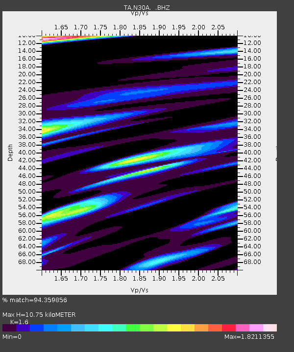
| Estimated Moho Depth: |
10.75 km |
| Estimated Crust Vp/Vs: |
1.60 |
| Assumed Crust Vp: |
6.483 km/s |
| Estimated Crust Vs: |
4.052 km/s |
| Estimated Crust Poisson's Ratio: |
0.18 |
|
| Radial Match: |
94.359856 % |
| Radial Bump: |
369 |
| Transverse Match: |
87.32896 % |
| Transverse Bump: |
400 |
| SOD ConfigId: |
2622 |
| Insert Time: |
2010-03-06 01:57:47.535 +0000 |
| GWidth: |
2.5 |
| Max Bumps: |
400 |
| Tol: |
0.001 |
|

Signal To Noise
| Channel | StoN | STA | LTA |
| TA:N30A: :BHZ:20090912T20:13:39.073992Z | 11.343604 | 2.7516874E-6 | 2.425761E-7 |
| TA:N30A: :BHN:20090912T20:13:39.073992Z | 3.6623583 | 1.39026E-6 | 3.7960785E-7 |
| TA:N30A: :BHE:20090912T20:13:39.073992Z | 4.190969 | 1.8274781E-6 | 4.3605144E-7 |
| Arrivals |
| Ps | 1.1 SECOND |
| PpPs | 4.0 SECOND |
| PsPs/PpSs | 5.1 SECOND |


