You are here: Home > Network List > TA - USArray Transportable Network (new EarthScope stations) Stations List
> Station N30A Hueftle Ranch, Cozad, NE, USA > Earthquake Result Viewer
N30A Hueftle Ranch, Cozad, NE, USA - Earthquake Result Viewer
| Earthquake location: |
Northern Mid-Atlantic Ridge |
| Earthquake latitude/longitude: |
23.9/-46.1 |
| Earthquake time(UTC): |
2009/06/06 (157) 20:33:28 GMT |
| Earthquake Depth: |
14 km |
| Earthquake Magnitude: |
6.0 MB, 5.7 MS, 6.0 MW, 6.0 MW |
| Earthquake Catalog/Contributor: |
WHDF/NEIC |
|
| Network: |
TA USArray Transportable Network (new EarthScope stations) |
| Station: |
N30A Hueftle Ranch, Cozad, NE, USA |
| Lat/Lon: |
40.80 N/100.10 W |
| Elevation: |
842 m |
|
| Distance: |
47.9 deg |
| Az: |
304.131 deg |
| Baz: |
93.465 deg |
| Ray Param: |
0.06968857 |
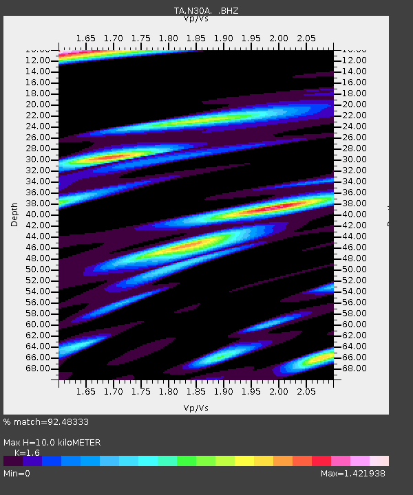
| Estimated Moho Depth: |
10.0 km |
| Estimated Crust Vp/Vs: |
1.60 |
| Assumed Crust Vp: |
6.483 km/s |
| Estimated Crust Vs: |
4.052 km/s |
| Estimated Crust Poisson's Ratio: |
0.18 |
|
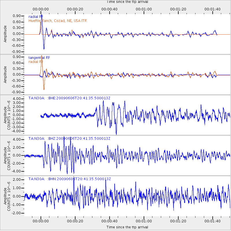
| Radial Match: |
92.48333 % |
| Radial Bump: |
341 |
| Transverse Match: |
74.21796 % |
| Transverse Bump: |
400 |
| SOD ConfigId: |
2648 |
| Insert Time: |
2010-03-06 01:57:55.878 +0000 |
| GWidth: |
2.5 |
| Max Bumps: |
400 |
| Tol: |
0.001 |
|
Signal To Noise
| Channel | StoN | STA | LTA |
| TA:N30A: :BHZ:20090606T20:41:35.500013Z | 10.727704 | 1.5980521E-6 | 1.4896496E-7 |
| TA:N30A: :BHN:20090606T20:41:35.500013Z | 1.827234 | 4.2322492E-7 | 2.3162053E-7 |
| TA:N30A: :BHE:20090606T20:41:35.500013Z | 4.257635 | 1.1519259E-6 | 2.7055532E-7 |
| Arrivals |
| Ps | 1.0 SECOND |
| PpPs | 3.7 SECOND |
| PsPs/PpSs | 4.7 SECOND |


