You are here: Home > Network List > SV - Servicio Nacional de Estudios Territoriales (SNET), El Salvador Stations List
> Station MTO3 Montecristo > Earthquake Result Viewer
MTO3 Montecristo - Earthquake Result Viewer
| Earthquake location: |
Komandorskiye Ostrova Region |
| Earthquake latitude/longitude: |
54.6/168.6 |
| Earthquake time(UTC): |
2017/07/17 (198) 11:05:08 GMT |
| Earthquake Depth: |
7.9 km |
| Earthquake Magnitude: |
6.2 Mww |
| Earthquake Catalog/Contributor: |
NEIC PDE/us |
|
| Network: |
SV Servicio Nacional de Estudios Territoriales (SNET), El Salvador |
| Station: |
MTO3 Montecristo |
| Lat/Lon: |
14.40 N/89.36 W |
| Elevation: |
1830 m |
|
| Distance: |
85.2 deg |
| Az: |
72.023 deg |
| Baz: |
325.15 deg |
| Ray Param: |
0.044940725 |
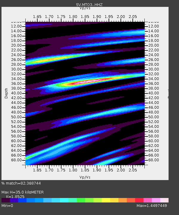
| Estimated Moho Depth: |
35.0 km |
| Estimated Crust Vp/Vs: |
1.85 |
| Assumed Crust Vp: |
6.597 km/s |
| Estimated Crust Vs: |
3.561 km/s |
| Estimated Crust Poisson's Ratio: |
0.29 |
|
| Radial Match: |
82.368744 % |
| Radial Bump: |
400 |
| Transverse Match: |
69.90068 % |
| Transverse Bump: |
400 |
| SOD ConfigId: |
13570011 |
| Insert Time: |
2019-04-28 09:56:09.181 +0000 |
| GWidth: |
2.5 |
| Max Bumps: |
400 |
| Tol: |
0.001 |
|

Signal To Noise
| Channel | StoN | STA | LTA |
| SV:MTO3: :HHZ:20170717T11:17:14.21002Z | 12.89947 | 6.8358054E-7 | 5.2992917E-8 |
| SV:MTO3: :HHN:20170717T11:17:14.21002Z | 5.6165004 | 2.464509E-7 | 4.3879798E-8 |
| SV:MTO3: :HHE:20170717T11:17:14.21002Z | 1.5145698 | 1.6643847E-7 | 1.0989159E-7 |
| Arrivals |
| Ps | 4.6 SECOND |
| PpPs | 15 SECOND |
| PsPs/PpSs | 19 SECOND |


