You are here: Home > Network List > TA - USArray Transportable Network (new EarthScope stations) Stations List
> Station MDND Maddock, ND, USA > Earthquake Result Viewer
MDND Maddock, ND, USA - Earthquake Result Viewer
| Earthquake location: |
Komandorskiye Ostrova Region |
| Earthquake latitude/longitude: |
54.6/168.6 |
| Earthquake time(UTC): |
2017/07/17 (198) 11:05:08 GMT |
| Earthquake Depth: |
7.9 km |
| Earthquake Magnitude: |
6.2 Mww |
| Earthquake Catalog/Contributor: |
NEIC PDE/us |
|
| Network: |
TA USArray Transportable Network (new EarthScope stations) |
| Station: |
MDND Maddock, ND, USA |
| Lat/Lon: |
47.85 N/99.60 W |
| Elevation: |
479 m |
|
| Distance: |
53.9 deg |
| Az: |
56.419 deg |
| Baz: |
313.945 deg |
| Ray Param: |
0.06578623 |
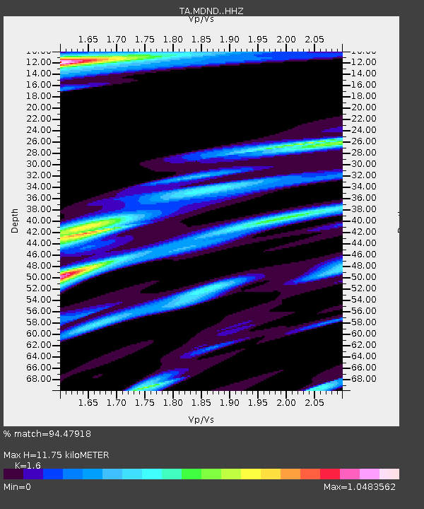
| Estimated Moho Depth: |
11.75 km |
| Estimated Crust Vp/Vs: |
1.60 |
| Assumed Crust Vp: |
6.53 km/s |
| Estimated Crust Vs: |
4.082 km/s |
| Estimated Crust Poisson's Ratio: |
0.18 |
|
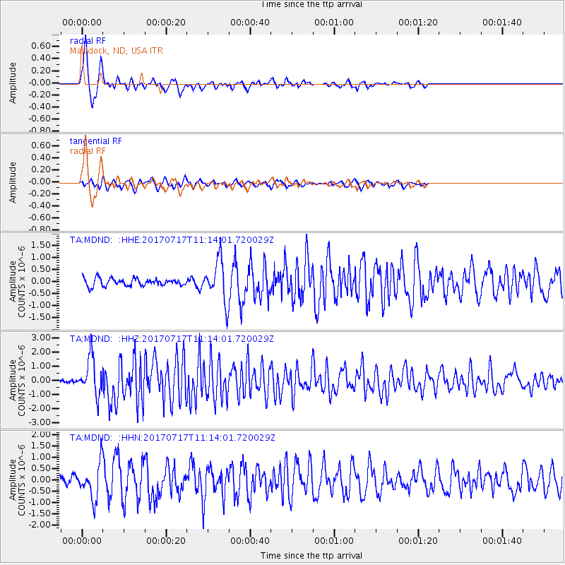
| Radial Match: |
94.47918 % |
| Radial Bump: |
363 |
| Transverse Match: |
75.57241 % |
| Transverse Bump: |
359 |
| SOD ConfigId: |
13570011 |
| Insert Time: |
2019-04-28 09:56:21.832 +0000 |
| GWidth: |
2.5 |
| Max Bumps: |
400 |
| Tol: |
0.001 |
|
Signal To Noise
| Channel | StoN | STA | LTA |
| TA:MDND: :HHZ:20170717T11:14:01.720029Z | 15.636044 | 1.3329795E-6 | 8.525044E-8 |
| TA:MDND: :HHN:20170717T11:14:01.720029Z | 4.7103624 | 8.0977526E-7 | 1.7191357E-7 |
| TA:MDND: :HHE:20170717T11:14:01.720029Z | 5.984982 | 9.0645125E-7 | 1.5145429E-7 |
| Arrivals |
| Ps | 1.1 SECOND |
| PpPs | 4.4 SECOND |
| PsPs/PpSs | 5.5 SECOND |


