You are here: Home > Network List > TA - USArray Transportable Network (new EarthScope stations) Stations List
> Station R11B Troy Canyon, Currant, NV, USA > Earthquake Result Viewer
R11B Troy Canyon, Currant, NV, USA - Earthquake Result Viewer
| Earthquake location: |
Komandorskiye Ostrova Region |
| Earthquake latitude/longitude: |
54.6/168.6 |
| Earthquake time(UTC): |
2017/07/17 (198) 11:05:08 GMT |
| Earthquake Depth: |
7.9 km |
| Earthquake Magnitude: |
6.2 Mww |
| Earthquake Catalog/Contributor: |
NEIC PDE/us |
|
| Network: |
TA USArray Transportable Network (new EarthScope stations) |
| Station: |
R11B Troy Canyon, Currant, NV, USA |
| Lat/Lon: |
38.35 N/115.59 W |
| Elevation: |
1767 m |
|
| Distance: |
52.1 deg |
| Az: |
75.12 deg |
| Baz: |
314.313 deg |
| Ray Param: |
0.0670129 |
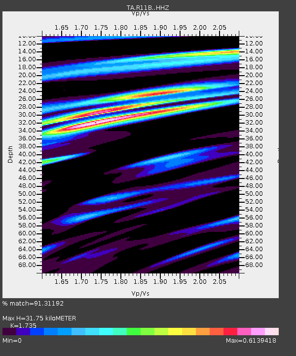
| Estimated Moho Depth: |
31.75 km |
| Estimated Crust Vp/Vs: |
1.74 |
| Assumed Crust Vp: |
6.276 km/s |
| Estimated Crust Vs: |
3.617 km/s |
| Estimated Crust Poisson's Ratio: |
0.25 |
|
| Radial Match: |
91.31192 % |
| Radial Bump: |
364 |
| Transverse Match: |
73.49725 % |
| Transverse Bump: |
400 |
| SOD ConfigId: |
13570011 |
| Insert Time: |
2019-04-28 09:56:30.991 +0000 |
| GWidth: |
2.5 |
| Max Bumps: |
400 |
| Tol: |
0.001 |
|

Signal To Noise
| Channel | StoN | STA | LTA |
| TA:R11B: :HHZ:20170717T11:13:48.020017Z | 20.721113 | 1.4523991E-6 | 7.009272E-8 |
| TA:R11B: :HHN:20170717T11:13:48.020017Z | 10.354966 | 5.020955E-7 | 4.848837E-8 |
| TA:R11B: :HHE:20170717T11:13:48.020017Z | 13.919944 | 5.562014E-7 | 3.995716E-8 |
| Arrivals |
| Ps | 3.9 SECOND |
| PpPs | 13 SECOND |
| PsPs/PpSs | 17 SECOND |


