You are here: Home > Network List > TA - USArray Transportable Network (new EarthScope stations) Stations List
> Station R33M Jennings River, BC, CAN > Earthquake Result Viewer
R33M Jennings River, BC, CAN - Earthquake Result Viewer
| Earthquake location: |
Komandorskiye Ostrova Region |
| Earthquake latitude/longitude: |
54.6/168.6 |
| Earthquake time(UTC): |
2017/07/17 (198) 11:05:08 GMT |
| Earthquake Depth: |
7.9 km |
| Earthquake Magnitude: |
6.2 Mww |
| Earthquake Catalog/Contributor: |
NEIC PDE/us |
|
| Network: |
TA USArray Transportable Network (new EarthScope stations) |
| Station: |
R33M Jennings River, BC, CAN |
| Lat/Lon: |
59.39 N/130.97 W |
| Elevation: |
1437 m |
|
| Distance: |
32.2 deg |
| Az: |
56.486 deg |
| Baz: |
288.453 deg |
| Ray Param: |
0.07873865 |
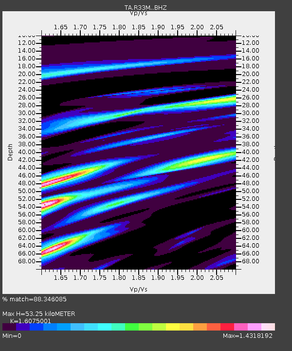
| Estimated Moho Depth: |
53.25 km |
| Estimated Crust Vp/Vs: |
1.61 |
| Assumed Crust Vp: |
6.597 km/s |
| Estimated Crust Vs: |
4.104 km/s |
| Estimated Crust Poisson's Ratio: |
0.18 |
|
| Radial Match: |
88.346085 % |
| Radial Bump: |
324 |
| Transverse Match: |
72.70065 % |
| Transverse Bump: |
400 |
| SOD ConfigId: |
13570011 |
| Insert Time: |
2019-04-28 09:56:32.493 +0000 |
| GWidth: |
2.5 |
| Max Bumps: |
400 |
| Tol: |
0.001 |
|

Signal To Noise
| Channel | StoN | STA | LTA |
| TA:R33M: :BHZ:20170717T11:11:06.999998Z | 35.74629 | 1.3317856E-6 | 3.7256612E-8 |
| TA:R33M: :BHN:20170717T11:11:06.999998Z | 17.70064 | 4.912655E-7 | 2.775411E-8 |
| TA:R33M: :BHE:20170717T11:11:06.999998Z | 20.385336 | 7.9940133E-7 | 3.9214527E-8 |
| Arrivals |
| Ps | 5.4 SECOND |
| PpPs | 19 SECOND |
| PsPs/PpSs | 25 SECOND |


