You are here: Home > Network List > TA - USArray Transportable Network (new EarthScope stations) Stations List
> Station T33K Petersburg, AK, USA > Earthquake Result Viewer
T33K Petersburg, AK, USA - Earthquake Result Viewer
| Earthquake location: |
Komandorskiye Ostrova Region |
| Earthquake latitude/longitude: |
54.6/168.6 |
| Earthquake time(UTC): |
2017/07/17 (198) 11:05:08 GMT |
| Earthquake Depth: |
7.9 km |
| Earthquake Magnitude: |
6.2 Mww |
| Earthquake Catalog/Contributor: |
NEIC PDE/us |
|
| Network: |
TA USArray Transportable Network (new EarthScope stations) |
| Station: |
T33K Petersburg, AK, USA |
| Lat/Lon: |
56.81 N/132.95 W |
| Elevation: |
22 m |
|
| Distance: |
32.1 deg |
| Az: |
61.728 deg |
| Baz: |
291.207 deg |
| Ray Param: |
0.07878707 |
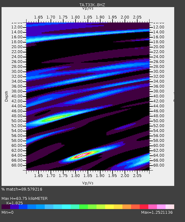
| Estimated Moho Depth: |
63.75 km |
| Estimated Crust Vp/Vs: |
1.83 |
| Assumed Crust Vp: |
6.597 km/s |
| Estimated Crust Vs: |
3.615 km/s |
| Estimated Crust Poisson's Ratio: |
0.29 |
|
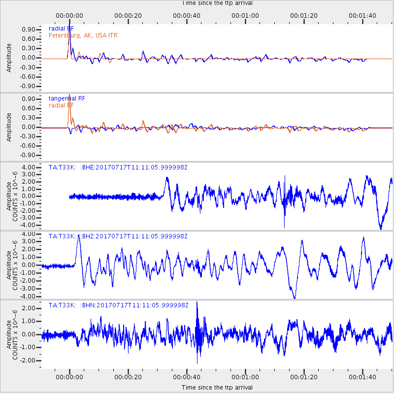
| Radial Match: |
89.579216 % |
| Radial Bump: |
365 |
| Transverse Match: |
73.29213 % |
| Transverse Bump: |
400 |
| SOD ConfigId: |
13570011 |
| Insert Time: |
2019-04-28 09:56:37.954 +0000 |
| GWidth: |
2.5 |
| Max Bumps: |
400 |
| Tol: |
0.001 |
|
Signal To Noise
| Channel | StoN | STA | LTA |
| TA:T33K: :BHZ:20170717T11:11:05.999998Z | 15.675155 | 1.7306648E-6 | 1.1040815E-7 |
| TA:T33K: :BHN:20170717T11:11:05.999998Z | 1.7803514 | 3.1483486E-7 | 1.768386E-7 |
| TA:T33K: :BHE:20170717T11:11:05.999998Z | 5.5602627 | 1.1710632E-6 | 2.1061294E-7 |
| Arrivals |
| Ps | 8.6 SECOND |
| PpPs | 25 SECOND |
| PsPs/PpSs | 34 SECOND |


