You are here: Home > Network List > TA - USArray Transportable Network (new EarthScope stations) Stations List
> Station TPFO Pinon Flats, CA, USA > Earthquake Result Viewer
TPFO Pinon Flats, CA, USA - Earthquake Result Viewer
| Earthquake location: |
Komandorskiye Ostrova Region |
| Earthquake latitude/longitude: |
54.6/168.6 |
| Earthquake time(UTC): |
2017/07/17 (198) 11:05:08 GMT |
| Earthquake Depth: |
7.9 km |
| Earthquake Magnitude: |
6.2 Mww |
| Earthquake Catalog/Contributor: |
NEIC PDE/us |
|
| Network: |
TA USArray Transportable Network (new EarthScope stations) |
| Station: |
TPFO Pinon Flats, CA, USA |
| Lat/Lon: |
33.61 N/116.45 W |
| Elevation: |
1275 m |
|
| Distance: |
54.9 deg |
| Az: |
79.874 deg |
| Baz: |
316.634 deg |
| Ray Param: |
0.06513279 |
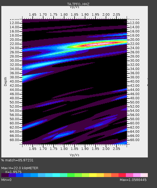
| Estimated Moho Depth: |
22.0 km |
| Estimated Crust Vp/Vs: |
1.96 |
| Assumed Crust Vp: |
6.264 km/s |
| Estimated Crust Vs: |
3.2 km/s |
| Estimated Crust Poisson's Ratio: |
0.32 |
|
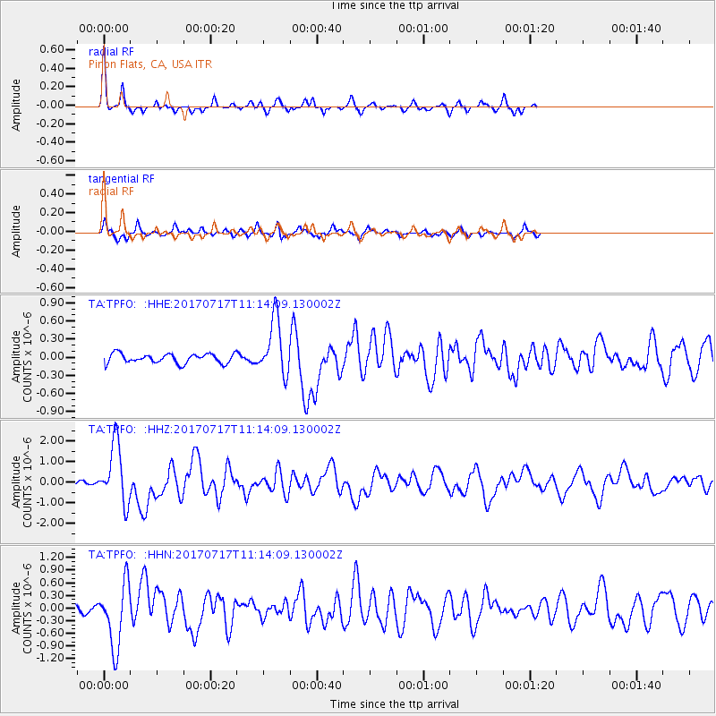
| Radial Match: |
85.97231 % |
| Radial Bump: |
254 |
| Transverse Match: |
79.52756 % |
| Transverse Bump: |
375 |
| SOD ConfigId: |
13570011 |
| Insert Time: |
2019-04-28 09:56:39.449 +0000 |
| GWidth: |
2.5 |
| Max Bumps: |
400 |
| Tol: |
0.001 |
|
Signal To Noise
| Channel | StoN | STA | LTA |
| TA:TPFO: :HHZ:20170717T11:14:09.130002Z | 10.487434 | 1.4623225E-6 | 1.3943567E-7 |
| TA:TPFO: :HHN:20170717T11:14:09.130002Z | 8.377854 | 7.661163E-7 | 9.144541E-8 |
| TA:TPFO: :HHE:20170717T11:14:09.130002Z | 5.9266953 | 4.7130257E-7 | 7.952198E-8 |
| Arrivals |
| Ps | 3.5 SECOND |
| PpPs | 9.9 SECOND |
| PsPs/PpSs | 13 SECOND |


