You are here: Home > Network List > TA - USArray Transportable Network (new EarthScope stations) Stations List
> Station U33K Whale Pass, AK, USA > Earthquake Result Viewer
U33K Whale Pass, AK, USA - Earthquake Result Viewer
| Earthquake location: |
Komandorskiye Ostrova Region |
| Earthquake latitude/longitude: |
54.6/168.6 |
| Earthquake time(UTC): |
2017/07/17 (198) 11:05:08 GMT |
| Earthquake Depth: |
7.9 km |
| Earthquake Magnitude: |
6.2 Mww |
| Earthquake Catalog/Contributor: |
NEIC PDE/us |
|
| Network: |
TA USArray Transportable Network (new EarthScope stations) |
| Station: |
U33K Whale Pass, AK, USA |
| Lat/Lon: |
56.11 N/133.12 W |
| Elevation: |
11 m |
|
| Distance: |
32.3 deg |
| Az: |
63.016 deg |
| Baz: |
292.157 deg |
| Ray Param: |
0.07871381 |
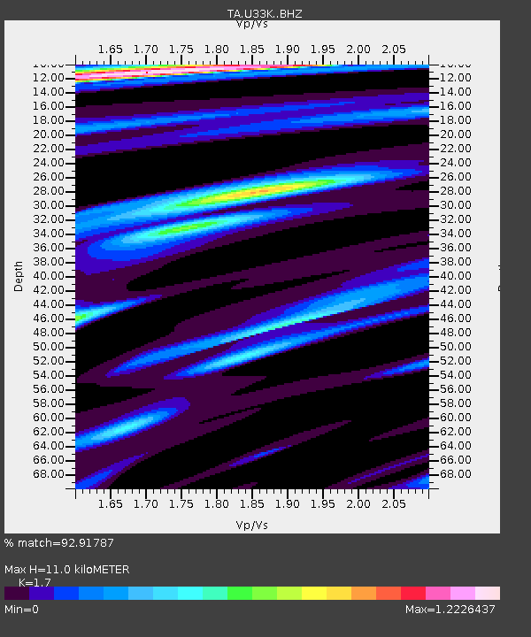
| Estimated Moho Depth: |
11.0 km |
| Estimated Crust Vp/Vs: |
1.70 |
| Assumed Crust Vp: |
6.597 km/s |
| Estimated Crust Vs: |
3.881 km/s |
| Estimated Crust Poisson's Ratio: |
0.24 |
|
| Radial Match: |
92.91787 % |
| Radial Bump: |
273 |
| Transverse Match: |
74.8335 % |
| Transverse Bump: |
400 |
| SOD ConfigId: |
13570011 |
| Insert Time: |
2019-04-28 09:56:40.318 +0000 |
| GWidth: |
2.5 |
| Max Bumps: |
400 |
| Tol: |
0.001 |
|
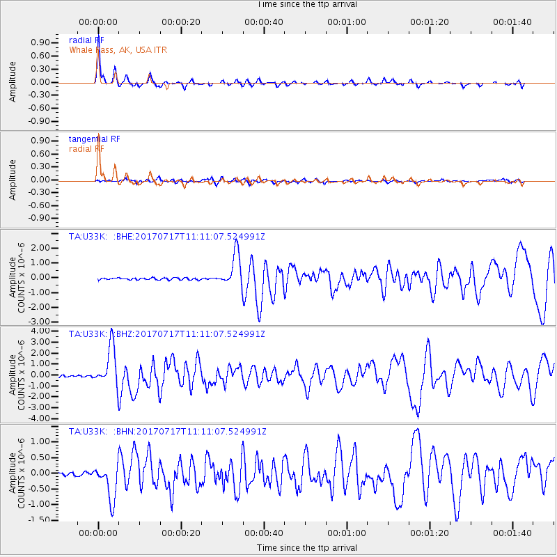
Signal To Noise
| Channel | StoN | STA | LTA |
| TA:U33K: :BHZ:20170717T11:11:07.524991Z | 27.846628 | 1.9053837E-6 | 6.8424214E-8 |
| TA:U33K: :BHN:20170717T11:11:07.524991Z | 10.305656 | 5.922869E-7 | 5.747202E-8 |
| TA:U33K: :BHE:20170717T11:11:07.524991Z | 18.059319 | 1.1736948E-6 | 6.499109E-8 |
| Arrivals |
| Ps | 1.3 SECOND |
| PpPs | 4.1 SECOND |
| PsPs/PpSs | 5.4 SECOND |


