You are here: Home > Network List > TA - USArray Transportable Network (new EarthScope stations) Stations List
> Station W18A Petrified Forest, AZ, USA > Earthquake Result Viewer
W18A Petrified Forest, AZ, USA - Earthquake Result Viewer
| Earthquake location: |
Komandorskiye Ostrova Region |
| Earthquake latitude/longitude: |
54.6/168.6 |
| Earthquake time(UTC): |
2017/07/17 (198) 11:05:08 GMT |
| Earthquake Depth: |
7.9 km |
| Earthquake Magnitude: |
6.2 Mww |
| Earthquake Catalog/Contributor: |
NEIC PDE/us |
|
| Network: |
TA USArray Transportable Network (new EarthScope stations) |
| Station: |
W18A Petrified Forest, AZ, USA |
| Lat/Lon: |
35.12 N/109.74 W |
| Elevation: |
1750 m |
|
| Distance: |
57.6 deg |
| Az: |
73.763 deg |
| Baz: |
317.017 deg |
| Ray Param: |
0.06336584 |
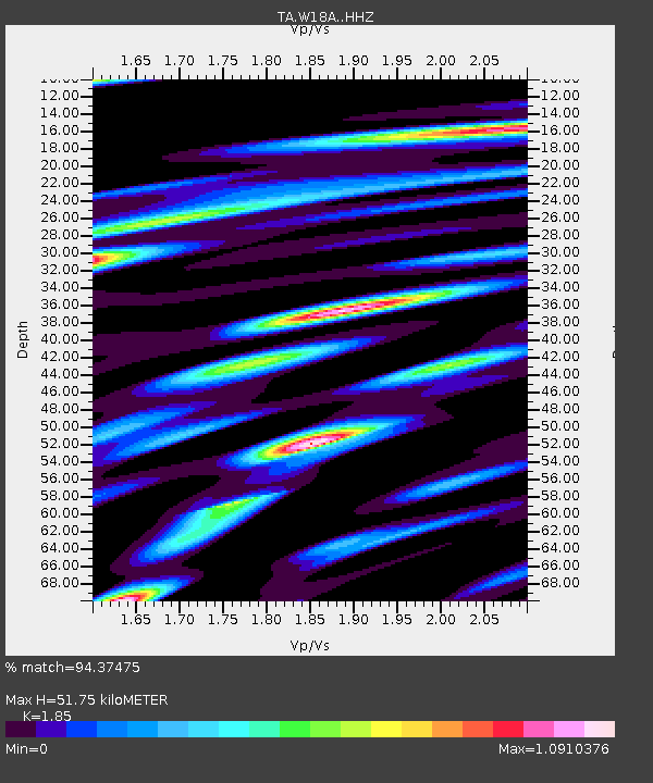
| Estimated Moho Depth: |
51.75 km |
| Estimated Crust Vp/Vs: |
1.85 |
| Assumed Crust Vp: |
6.496 km/s |
| Estimated Crust Vs: |
3.511 km/s |
| Estimated Crust Poisson's Ratio: |
0.29 |
|
| Radial Match: |
94.37475 % |
| Radial Bump: |
382 |
| Transverse Match: |
75.541405 % |
| Transverse Bump: |
400 |
| SOD ConfigId: |
13570011 |
| Insert Time: |
2019-04-28 09:56:41.977 +0000 |
| GWidth: |
2.5 |
| Max Bumps: |
400 |
| Tol: |
0.001 |
|

Signal To Noise
| Channel | StoN | STA | LTA |
| TA:W18A: :HHZ:20170717T11:14:28.409971Z | 29.920267 | 1.5710641E-6 | 5.2508355E-8 |
| TA:W18A: :HHN:20170717T11:14:28.409971Z | 10.112338 | 6.2173797E-7 | 6.148311E-8 |
| TA:W18A: :HHE:20170717T11:14:28.409971Z | 12.607708 | 7.854135E-7 | 6.2296294E-8 |
| Arrivals |
| Ps | 7.1 SECOND |
| PpPs | 22 SECOND |
| PsPs/PpSs | 29 SECOND |


