You are here: Home > Network List > TD - TransAlta Monitoring Network Stations List
> Station TD008 Z > Earthquake Result Viewer
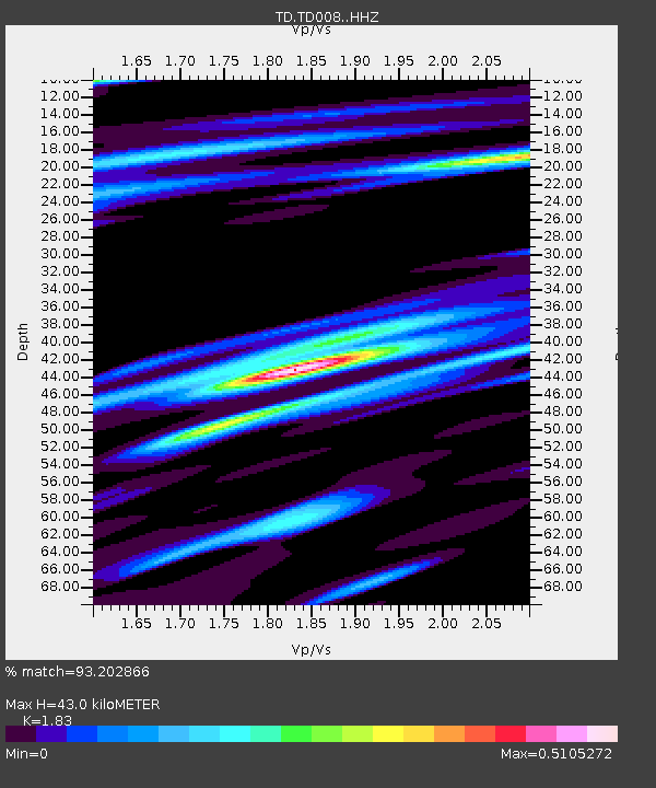
TD008 Z - Earthquake Result Viewer
| Earthquake location: |
Komandorskiye Ostrova Region |
| Earthquake latitude/longitude: |
54.6/168.6 |
| Earthquake time(UTC): |
2017/07/17 (198) 11:05:08 GMT |
| Earthquake Depth: |
7.9 km |
| Earthquake Magnitude: |
6.2 Mww |
| Earthquake Catalog/Contributor: |
NEIC PDE/us |
|
| Network: |
TD TransAlta Monitoring Network |
| Station: |
TD008 Z |
| Lat/Lon: |
52.80 N/115.43 W |
| Elevation: |
964 m |
|
| Distance: |
42.9 deg |
| Az: |
59.819 deg |
| Baz: |
304.019 deg |
| Ray Param: |
0.07287561 |
| Estimated Moho Depth: |
43.0 km |
| Estimated Crust Vp/Vs: |
1.83 |
| Assumed Crust Vp: |
6.426 km/s |
| Estimated Crust Vs: |
3.512 km/s |
| Estimated Crust Poisson's Ratio: |
0.29 |
|
| Radial Match: |
93.202866 % |
| Radial Bump: |
394 |
| Transverse Match: |
80.668785 % |
| Transverse Bump: |
400 |
| SOD ConfigId: |
13570011 |
| Insert Time: |
2019-04-28 09:56:51.984 +0000 |
| GWidth: |
2.5 |
| Max Bumps: |
400 |
| Tol: |
0.001 |
|

Signal To Noise
| Channel | StoN | STA | LTA |
| TD:TD008: :HHZ:20170717T11:12:37.269987Z | 24.626 | 2.0797252E-6 | 8.445242E-8 |
| TD:TD008: :HH1:20170717T11:12:37.269987Z | 7.232369 | 4.329835E-7 | 5.986745E-8 |
| TD:TD008: :HH2:20170717T11:12:37.269987Z | 19.74169 | 1.0159139E-6 | 5.1460333E-8 |
| Arrivals |
| Ps | 5.9 SECOND |
| PpPs | 18 SECOND |
| PsPs/PpSs | 24 SECOND |


