You are here: Home > Network List > TJ - Tajikistan National Seismic Network Stations List
> Station GEZN Gezan, Tajikistan > Earthquake Result Viewer
GEZN Gezan, Tajikistan - Earthquake Result Viewer
| Earthquake location: |
Komandorskiye Ostrova Region |
| Earthquake latitude/longitude: |
54.6/168.6 |
| Earthquake time(UTC): |
2017/07/17 (198) 11:05:08 GMT |
| Earthquake Depth: |
7.9 km |
| Earthquake Magnitude: |
6.2 Mww |
| Earthquake Catalog/Contributor: |
NEIC PDE/us |
|
| Network: |
TJ Tajikistan National Seismic Network |
| Station: |
GEZN Gezan, Tajikistan |
| Lat/Lon: |
39.28 N/67.72 E |
| Elevation: |
1485 m |
|
| Distance: |
64.7 deg |
| Az: |
302.57 deg |
| Baz: |
39.206 deg |
| Ray Param: |
0.058746733 |
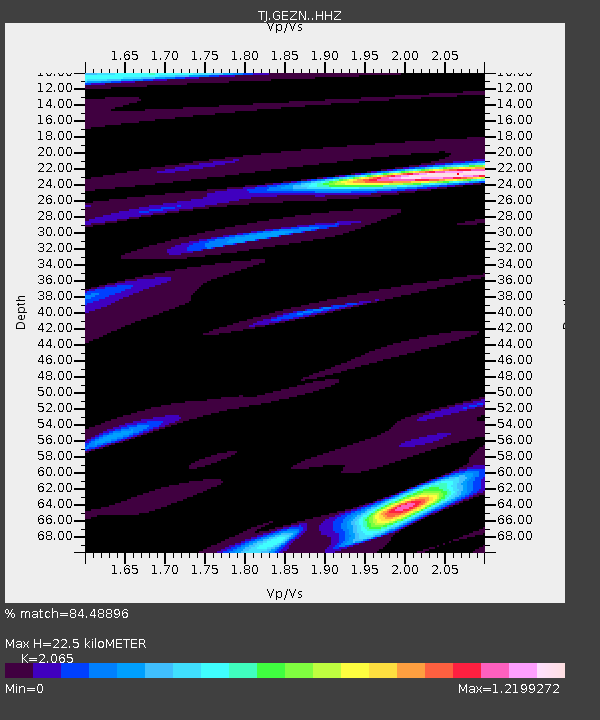
| Estimated Moho Depth: |
22.5 km |
| Estimated Crust Vp/Vs: |
2.07 |
| Assumed Crust Vp: |
6.444 km/s |
| Estimated Crust Vs: |
3.121 km/s |
| Estimated Crust Poisson's Ratio: |
0.35 |
|
| Radial Match: |
84.48896 % |
| Radial Bump: |
400 |
| Transverse Match: |
60.80987 % |
| Transverse Bump: |
400 |
| SOD ConfigId: |
13570011 |
| Insert Time: |
2019-04-28 09:56:57.217 +0000 |
| GWidth: |
2.5 |
| Max Bumps: |
400 |
| Tol: |
0.001 |
|
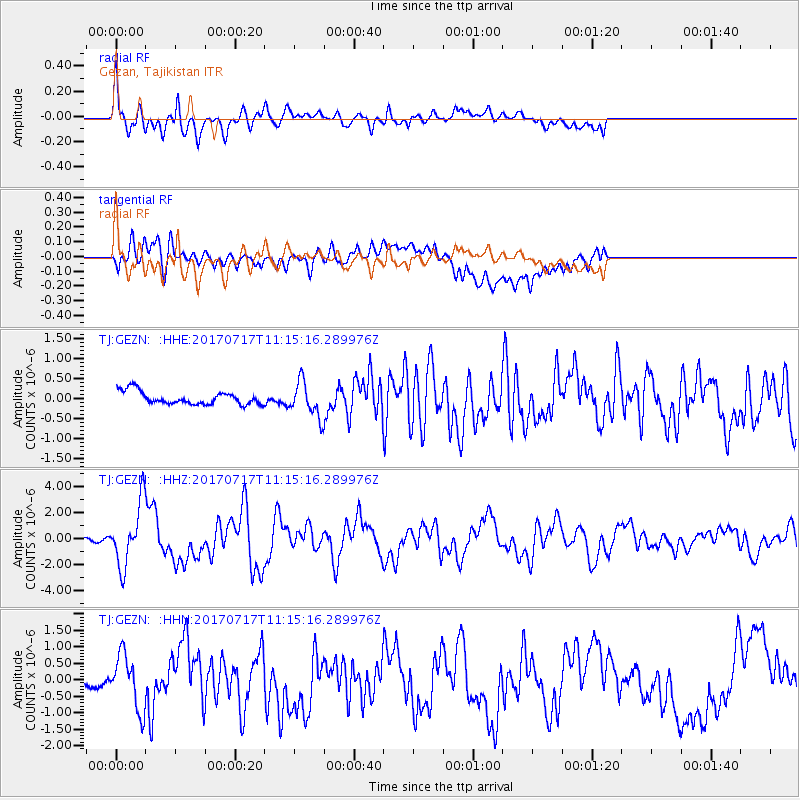
Signal To Noise
| Channel | StoN | STA | LTA |
| TJ:GEZN: :HHZ:20170717T11:15:16.289976Z | 20.822836 | 2.4384015E-6 | 1.17102275E-7 |
| TJ:GEZN: :HHN:20170717T11:15:16.289976Z | 2.6739933 | 8.369594E-7 | 3.1299982E-7 |
| TJ:GEZN: :HHE:20170717T11:15:16.289976Z | 2.8265135 | 4.55956E-7 | 1.6131393E-7 |
| Arrivals |
| Ps | 3.9 SECOND |
| PpPs | 10 SECOND |
| PsPs/PpSs | 14 SECOND |


