You are here: Home > Network List > UW - Pacific Northwest Regional Seismic Network Stations List
> Station YACT Amboy, WA, USA > Earthquake Result Viewer
YACT Amboy, WA, USA - Earthquake Result Viewer

| Earthquake location: |
Komandorskiye Ostrova Region |
| Earthquake latitude/longitude: |
54.6/168.6 |
| Earthquake time(UTC): |
2017/07/17 (198) 11:05:08 GMT |
| Earthquake Depth: |
7.9 km |
| Earthquake Magnitude: |
6.2 Mww |
| Earthquake Catalog/Contributor: |
NEIC PDE/us |
|
| Network: |
UW Pacific Northwest Regional Seismic Network |
| Station: |
YACT Amboy, WA, USA |
| Lat/Lon: |
45.93 N/122.42 W |
| Elevation: |
211 m |
|
| Distance: |
43.3 deg |
| Az: |
71.895 deg |
| Baz: |
307.552 deg |
| Ray Param: |
0.07267843 |
| Estimated Moho Depth: |
12.75 km |
| Estimated Crust Vp/Vs: |
1.62 |
| Assumed Crust Vp: |
6.566 km/s |
| Estimated Crust Vs: |
4.047 km/s |
| Estimated Crust Poisson's Ratio: |
0.19 |
|
| Radial Match: |
84.32505 % |
| Radial Bump: |
400 |
| Transverse Match: |
74.56114 % |
| Transverse Bump: |
400 |
| SOD ConfigId: |
13570011 |
| Insert Time: |
2019-04-28 09:57:53.781 +0000 |
| GWidth: |
2.5 |
| Max Bumps: |
400 |
| Tol: |
0.001 |
|
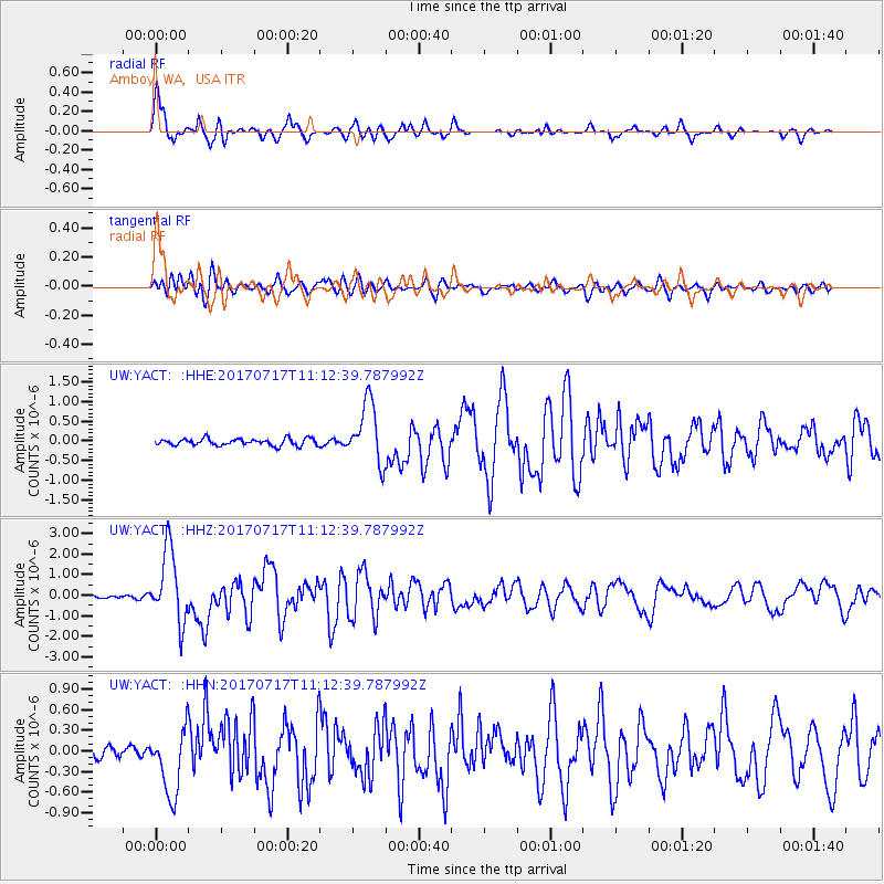
Signal To Noise
| Channel | StoN | STA | LTA |
| UW:YACT: :HHZ:20170717T11:12:39.787992Z | 15.6794195 | 1.7486663E-6 | 1.11526205E-7 |
| UW:YACT: :HHN:20170717T11:12:39.787992Z | 6.8134313 | 4.788468E-7 | 7.027983E-8 |
| UW:YACT: :HHE:20170717T11:12:39.787992Z | 8.842981 | 7.697867E-7 | 8.705059E-8 |
| Arrivals |
| Ps | 1.3 SECOND |
| PpPs | 4.7 SECOND |
| PsPs/PpSs | 6.0 SECOND |


