You are here: Home > Network List > WU - The Southern Ontario Seismic Network Stations List
> Station DELO Deloro Mine, Ontario, Canada > Earthquake Result Viewer
DELO Deloro Mine, Ontario, Canada - Earthquake Result Viewer
| Earthquake location: |
Komandorskiye Ostrova Region |
| Earthquake latitude/longitude: |
54.6/168.6 |
| Earthquake time(UTC): |
2017/07/17 (198) 11:05:08 GMT |
| Earthquake Depth: |
7.9 km |
| Earthquake Magnitude: |
6.2 Mww |
| Earthquake Catalog/Contributor: |
NEIC PDE/us |
|
| Network: |
WU The Southern Ontario Seismic Network |
| Station: |
DELO Deloro Mine, Ontario, Canada |
| Lat/Lon: |
44.52 N/77.62 W |
| Elevation: |
213 m |
|
| Distance: |
66.4 deg |
| Az: |
45.619 deg |
| Baz: |
324.438 deg |
| Ray Param: |
0.057652578 |
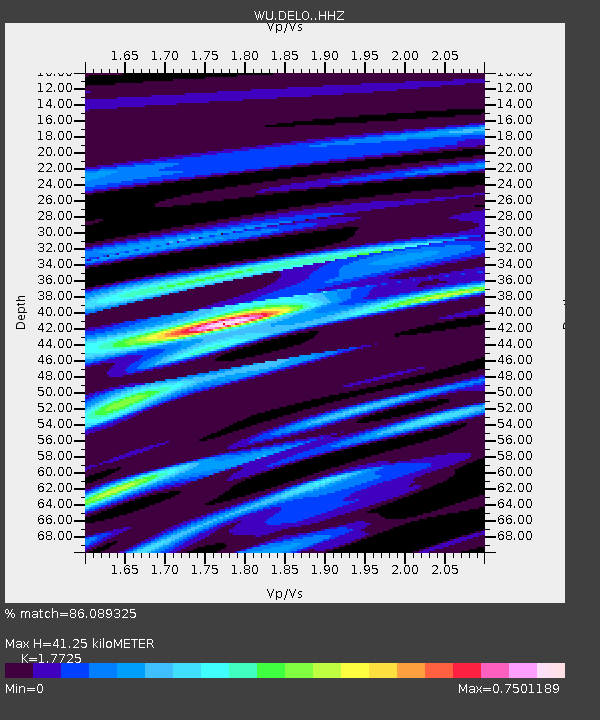
| Estimated Moho Depth: |
41.25 km |
| Estimated Crust Vp/Vs: |
1.77 |
| Assumed Crust Vp: |
6.577 km/s |
| Estimated Crust Vs: |
3.711 km/s |
| Estimated Crust Poisson's Ratio: |
0.27 |
|
| Radial Match: |
86.089325 % |
| Radial Bump: |
330 |
| Transverse Match: |
69.47015 % |
| Transverse Bump: |
400 |
| SOD ConfigId: |
13570011 |
| Insert Time: |
2019-04-28 09:58:00.597 +0000 |
| GWidth: |
2.5 |
| Max Bumps: |
400 |
| Tol: |
0.001 |
|

Signal To Noise
| Channel | StoN | STA | LTA |
| WU:DELO: :HHZ:20170717T11:15:27.070005Z | 7.060651 | 4.2720887E-7 | 6.050559E-8 |
| WU:DELO: :HHN:20170717T11:15:27.070005Z | 2.7969384 | 1.7553411E-7 | 6.2759376E-8 |
| WU:DELO: :HHE:20170717T11:15:27.070005Z | 1.6044055 | 7.8828364E-8 | 4.9132442E-8 |
| Arrivals |
| Ps | 5.1 SECOND |
| PpPs | 17 SECOND |
| PsPs/PpSs | 22 SECOND |


