You are here: Home > Network List > X416 - Monitoring Active Faults for Tectonic Mapping Efforts in Washington State Stations List
> Station MA08 Snohomish County, WA, USA > Earthquake Result Viewer
MA08 Snohomish County, WA, USA - Earthquake Result Viewer
| Earthquake location: |
Komandorskiye Ostrova Region |
| Earthquake latitude/longitude: |
54.6/168.6 |
| Earthquake time(UTC): |
2017/07/17 (198) 11:05:08 GMT |
| Earthquake Depth: |
7.9 km |
| Earthquake Magnitude: |
6.2 Mww |
| Earthquake Catalog/Contributor: |
NEIC PDE/us |
|
| Network: |
X4 Monitoring Active Faults for Tectonic Mapping Efforts in Washington State |
| Station: |
MA08 Snohomish County, WA, USA |
| Lat/Lon: |
47.78 N/121.82 W |
| Elevation: |
-1.0 m |
|
| Distance: |
42.5 deg |
| Az: |
69.362 deg |
| Baz: |
306.13 deg |
| Ray Param: |
0.07316016 |
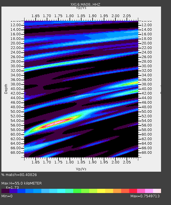
| Estimated Moho Depth: |
55.0 km |
| Estimated Crust Vp/Vs: |
1.73 |
| Assumed Crust Vp: |
6.597 km/s |
| Estimated Crust Vs: |
3.814 km/s |
| Estimated Crust Poisson's Ratio: |
0.25 |
|
| Radial Match: |
80.40826 % |
| Radial Bump: |
400 |
| Transverse Match: |
69.734726 % |
| Transverse Bump: |
400 |
| SOD ConfigId: |
13570011 |
| Insert Time: |
2019-04-28 09:58:14.465 +0000 |
| GWidth: |
2.5 |
| Max Bumps: |
400 |
| Tol: |
0.001 |
|

Signal To Noise
| Channel | StoN | STA | LTA |
| X4:MA08: :HHZ:20170717T11:12:33.485013Z | 40.646095 | 1.8931887E-6 | 4.657738E-8 |
| X4:MA08: :HHN:20170717T11:12:33.485013Z | 10.57069 | 6.8227433E-7 | 6.4543975E-8 |
| X4:MA08: :HHE:20170717T11:12:33.485013Z | 14.796972 | 8.2783725E-7 | 5.594639E-8 |
| Arrivals |
| Ps | 6.5 SECOND |
| PpPs | 21 SECOND |
| PsPs/PpSs | 28 SECOND |


