You are here: Home > Network List > TA - USArray Transportable Network (new EarthScope stations) Stations List
> Station O30A M W Ranch, Wilsonville, NE, USA > Earthquake Result Viewer
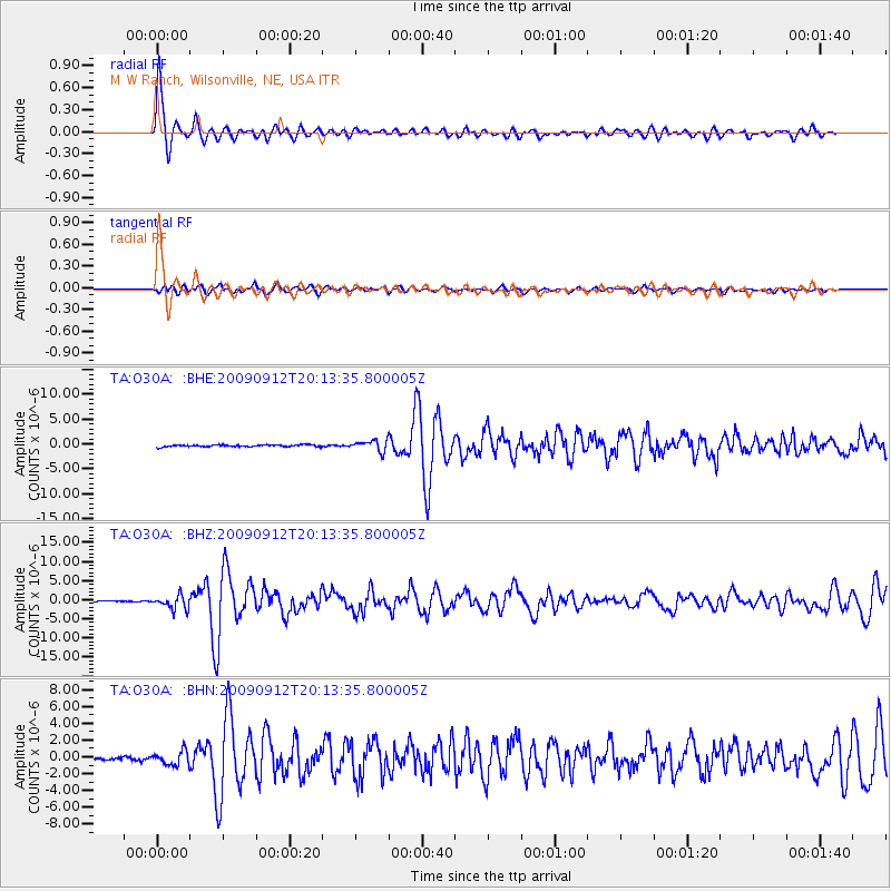
O30A M W Ranch, Wilsonville, NE, USA - Earthquake Result Viewer
| Earthquake location: |
Near Coast Of Venezuela |
| Earthquake latitude/longitude: |
10.7/-67.9 |
| Earthquake time(UTC): |
2009/09/12 (255) 20:06:24 GMT |
| Earthquake Depth: |
10 km |
| Earthquake Magnitude: |
6.3 MB, 6.4 MS, 6.3 MW, 6.3 MW |
| Earthquake Catalog/Contributor: |
WHDF/NEIC |
|
| Network: |
TA USArray Transportable Network (new EarthScope stations) |
| Station: |
O30A M W Ranch, Wilsonville, NE, USA |
| Lat/Lon: |
40.18 N/100.06 W |
| Elevation: |
751 m |
|
| Distance: |
40.9 deg |
| Az: |
321.473 deg |
| Baz: |
126.963 deg |
| Ray Param: |
0.074146256 |
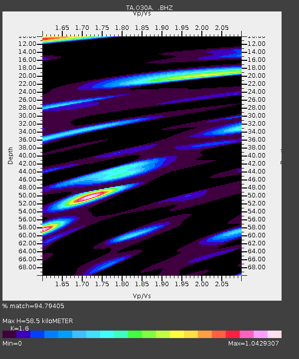
| Estimated Moho Depth: |
58.5 km |
| Estimated Crust Vp/Vs: |
1.60 |
| Assumed Crust Vp: |
6.483 km/s |
| Estimated Crust Vs: |
4.052 km/s |
| Estimated Crust Poisson's Ratio: |
0.18 |
|
| Radial Match: |
94.79405 % |
| Radial Bump: |
386 |
| Transverse Match: |
76.312225 % |
| Transverse Bump: |
400 |
| SOD ConfigId: |
2622 |
| Insert Time: |
2010-03-06 01:58:49.690 +0000 |
| GWidth: |
2.5 |
| Max Bumps: |
400 |
| Tol: |
0.001 |
|
Signal To Noise
| Channel | StoN | STA | LTA |
| TA:O30A: :BHZ:20090912T20:13:35.800005Z | 12.990967 | 1.7596036E-6 | 1.3544825E-7 |
| TA:O30A: :BHN:20090912T20:13:35.800005Z | 3.6823266 | 8.460103E-7 | 2.2974885E-7 |
| TA:O30A: :BHE:20090912T20:13:35.800005Z | 5.6464458 | 1.0988957E-6 | 1.9461724E-7 |
| Arrivals |
| Ps | 5.9 SECOND |
| PpPs | 22 SECOND |
| PsPs/PpSs | 28 SECOND |


