You are here: Home > Network List > TA - USArray Transportable Network (new EarthScope stations) Stations List
> Station O30A M W Ranch, Wilsonville, NE, USA > Earthquake Result Viewer
O30A M W Ranch, Wilsonville, NE, USA - Earthquake Result Viewer
| Earthquake location: |
Northern Mid-Atlantic Ridge |
| Earthquake latitude/longitude: |
23.9/-46.1 |
| Earthquake time(UTC): |
2009/06/06 (157) 20:33:28 GMT |
| Earthquake Depth: |
14 km |
| Earthquake Magnitude: |
6.0 MB, 5.7 MS, 6.0 MW, 6.0 MW |
| Earthquake Catalog/Contributor: |
WHDF/NEIC |
|
| Network: |
TA USArray Transportable Network (new EarthScope stations) |
| Station: |
O30A M W Ranch, Wilsonville, NE, USA |
| Lat/Lon: |
40.18 N/100.06 W |
| Elevation: |
751 m |
|
| Distance: |
47.8 deg |
| Az: |
303.304 deg |
| Baz: |
92.938 deg |
| Ray Param: |
0.069730334 |
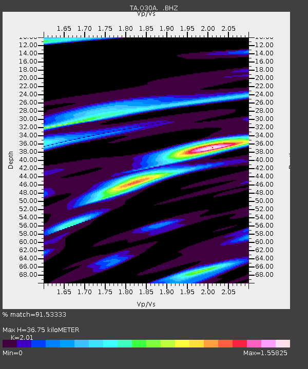
| Estimated Moho Depth: |
36.75 km |
| Estimated Crust Vp/Vs: |
2.01 |
| Assumed Crust Vp: |
6.483 km/s |
| Estimated Crust Vs: |
3.225 km/s |
| Estimated Crust Poisson's Ratio: |
0.34 |
|
| Radial Match: |
91.53333 % |
| Radial Bump: |
400 |
| Transverse Match: |
70.97211 % |
| Transverse Bump: |
400 |
| SOD ConfigId: |
2648 |
| Insert Time: |
2010-03-06 01:59:03.499 +0000 |
| GWidth: |
2.5 |
| Max Bumps: |
400 |
| Tol: |
0.001 |
|

Signal To Noise
| Channel | StoN | STA | LTA |
| TA:O30A: :BHZ:20090606T20:41:34.974012Z | 12.837462 | 1.0146576E-6 | 7.90388E-8 |
| TA:O30A: :BHN:20090606T20:41:34.974012Z | 2.0860374 | 2.5005002E-7 | 1.1986842E-7 |
| TA:O30A: :BHE:20090606T20:41:34.974012Z | 4.3093095 | 6.645653E-7 | 1.542162E-7 |
| Arrivals |
| Ps | 6.0 SECOND |
| PpPs | 16 SECOND |
| PsPs/PpSs | 22 SECOND |


