You are here: Home > Network List > US - United States National Seismic Network Stations List
> Station EGMT Eagleton, Montana, USA > Earthquake Result Viewer
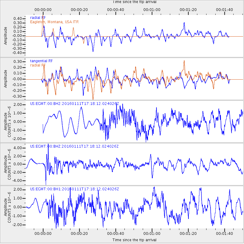
EGMT Eagleton, Montana, USA - Earthquake Result Viewer
*The percent match for this event was below the threshold and hence no stack was calculated.
| Earthquake location: |
Hokkaido, Japan Region |
| Earthquake latitude/longitude: |
44.5/141.1 |
| Earthquake time(UTC): |
2016/01/11 (011) 17:08:03 GMT |
| Earthquake Depth: |
240 km |
| Earthquake Magnitude: |
6.2 MWW |
| Earthquake Catalog/Contributor: |
NEIC PDE/NEIC COMCAT |
|
| Network: |
US United States National Seismic Network |
| Station: |
EGMT Eagleton, Montana, USA |
| Lat/Lon: |
48.02 N/109.75 W |
| Elevation: |
1055 m |
|
| Distance: |
68.9 deg |
| Az: |
42.807 deg |
| Baz: |
313.547 deg |
| Ray Param: |
$rayparam |
*The percent match for this event was below the threshold and hence was not used in the summary stack. |
|
| Radial Match: |
48.40543 % |
| Radial Bump: |
400 |
| Transverse Match: |
54.645523 % |
| Transverse Bump: |
400 |
| SOD ConfigId: |
1399611 |
| Insert Time: |
2016-01-25 17:45:05.483 +0000 |
| GWidth: |
2.5 |
| Max Bumps: |
400 |
| Tol: |
0.001 |
|
Signal To Noise
| Channel | StoN | STA | LTA |
| US:EGMT:00:BHZ:20160111T17:18:12.024026Z | 2.692498 | 1.6577319E-6 | 6.156855E-7 |
| US:EGMT:00:BH1:20160111T17:18:12.024026Z | 1.4141884 | 6.615829E-7 | 4.678181E-7 |
| US:EGMT:00:BH2:20160111T17:18:12.024026Z | 0.7069624 | 6.6056367E-7 | 9.3436887E-7 |
| Arrivals |
| Ps | |
| PpPs | |
| PsPs/PpSs | |


