You are here: Home > Network List > AZ - ANZA Regional Network Stations List
> Station SMER AZ.SMER > Earthquake Result Viewer
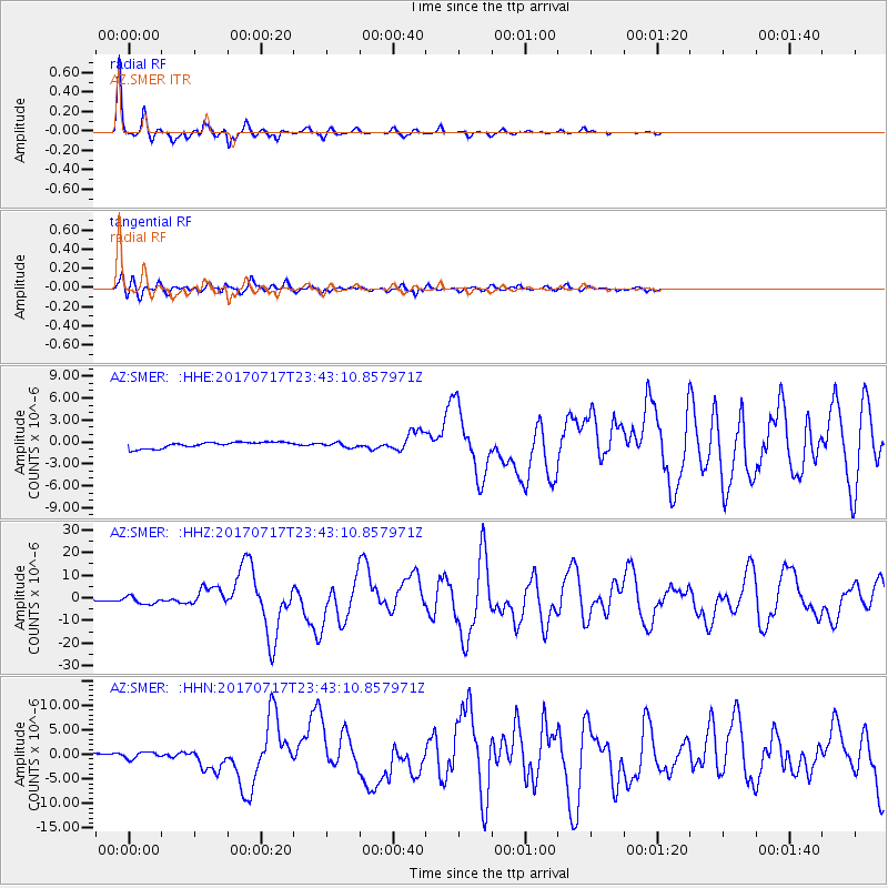
SMER AZ.SMER - Earthquake Result Viewer
*The percent match for this event was below the threshold and hence no stack was calculated.
| Earthquake location: |
Komandorskiye Ostrova Region |
| Earthquake latitude/longitude: |
54.2/169.2 |
| Earthquake time(UTC): |
2017/07/17 (198) 23:34:21 GMT |
| Earthquake Depth: |
48 km |
| Earthquake Magnitude: |
7.4 Mi |
| Earthquake Catalog/Contributor: |
NEIC PDE/pt |
|
| Network: |
AZ ANZA Regional Network |
| Station: |
SMER AZ.SMER |
| Lat/Lon: |
33.46 N/117.17 W |
| Elevation: |
355 m |
|
| Distance: |
54.4 deg |
| Az: |
80.673 deg |
| Baz: |
316.091 deg |
| Ray Param: |
$rayparam |
*The percent match for this event was below the threshold and hence was not used in the summary stack. |
|
| Radial Match: |
98.371574 % |
| Radial Bump: |
223 |
| Transverse Match: |
91.98423 % |
| Transverse Bump: |
400 |
| SOD ConfigId: |
13570011 |
| Insert Time: |
2019-04-28 09:59:48.049 +0000 |
| GWidth: |
2.5 |
| Max Bumps: |
400 |
| Tol: |
0.001 |
|
Signal To Noise
| Channel | StoN | STA | LTA |
| AZ:SMER: :HHZ:20170717T23:43:10.857971Z | 9.175167 | 1.6607929E-6 | 1.8100955E-7 |
| AZ:SMER: :HHN:20170717T23:43:10.857971Z | 1.2028345 | 6.7314517E-7 | 5.596324E-7 |
| AZ:SMER: :HHE:20170717T23:43:10.857971Z | 0.97368026 | 3.4421873E-7 | 3.535234E-7 |
| Arrivals |
| Ps | |
| PpPs | |
| PsPs/PpSs | |


