You are here: Home > Network List > CC - Cascade Chain Volcano Monitoring Stations List
> Station TMBU Tom Butte, Newberry, OR > Earthquake Result Viewer
TMBU Tom Butte, Newberry, OR - Earthquake Result Viewer
| Earthquake location: |
Komandorskiye Ostrova Region |
| Earthquake latitude/longitude: |
54.2/169.2 |
| Earthquake time(UTC): |
2017/07/17 (198) 23:34:21 GMT |
| Earthquake Depth: |
48 km |
| Earthquake Magnitude: |
7.4 Mi |
| Earthquake Catalog/Contributor: |
NEIC PDE/pt |
|
| Network: |
CC Cascade Chain Volcano Monitoring |
| Station: |
TMBU Tom Butte, Newberry, OR |
| Lat/Lon: |
43.60 N/121.14 W |
| Elevation: |
1743 m |
|
| Distance: |
45.2 deg |
| Az: |
73.683 deg |
| Baz: |
309.086 deg |
| Ray Param: |
0.07129663 |
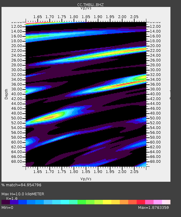
| Estimated Moho Depth: |
10.0 km |
| Estimated Crust Vp/Vs: |
1.60 |
| Assumed Crust Vp: |
6.597 km/s |
| Estimated Crust Vs: |
4.123 km/s |
| Estimated Crust Poisson's Ratio: |
0.18 |
|
| Radial Match: |
94.954796 % |
| Radial Bump: |
400 |
| Transverse Match: |
87.62851 % |
| Transverse Bump: |
400 |
| SOD ConfigId: |
13570011 |
| Insert Time: |
2019-04-28 10:00:26.594 +0000 |
| GWidth: |
2.5 |
| Max Bumps: |
400 |
| Tol: |
0.001 |
|

Signal To Noise
| Channel | StoN | STA | LTA |
| CC:TMBU: :BHZ:20170717T23:42:01.079987Z | 9.575264 | 2.0537284E-6 | 2.144827E-7 |
| CC:TMBU: :BHN:20170717T23:42:01.079987Z | 4.51106 | 7.714065E-7 | 1.7100338E-7 |
| CC:TMBU: :BHE:20170717T23:42:01.079987Z | 5.0157423 | 1.1353472E-6 | 2.2635679E-7 |
| Arrivals |
| Ps | 1.0 SECOND |
| PpPs | 3.7 SECOND |
| PsPs/PpSs | 4.6 SECOND |


