You are here: Home > Network List > US - United States National Seismic Network Stations List
> Station MNTX Cornudas Mountains, Texas, USA > Earthquake Result Viewer
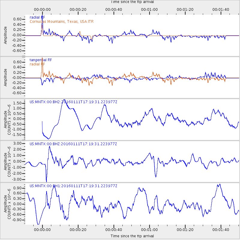
MNTX Cornudas Mountains, Texas, USA - Earthquake Result Viewer
*The percent match for this event was below the threshold and hence no stack was calculated.
| Earthquake location: |
Hokkaido, Japan Region |
| Earthquake latitude/longitude: |
44.5/141.1 |
| Earthquake time(UTC): |
2016/01/11 (011) 17:08:03 GMT |
| Earthquake Depth: |
240 km |
| Earthquake Magnitude: |
6.2 MWW |
| Earthquake Catalog/Contributor: |
NEIC PDE/NEIC COMCAT |
|
| Network: |
US United States National Seismic Network |
| Station: |
MNTX Cornudas Mountains, Texas, USA |
| Lat/Lon: |
31.70 N/105.38 W |
| Elevation: |
404 m |
|
| Distance: |
83.0 deg |
| Az: |
51.93 deg |
| Baz: |
318.6 deg |
| Ray Param: |
$rayparam |
*The percent match for this event was below the threshold and hence was not used in the summary stack. |
|
| Radial Match: |
69.50422 % |
| Radial Bump: |
400 |
| Transverse Match: |
71.77677 % |
| Transverse Bump: |
400 |
| SOD ConfigId: |
1399611 |
| Insert Time: |
2016-01-25 17:46:12.454 +0000 |
| GWidth: |
2.5 |
| Max Bumps: |
400 |
| Tol: |
0.001 |
|
Signal To Noise
| Channel | StoN | STA | LTA |
| US:MNTX:00:BHZ:20160111T17:19:31.223977Z | 1.7770709 | 1.4725108E-6 | 8.2861675E-7 |
| US:MNTX:00:BH1:20160111T17:19:31.223977Z | 0.57569444 | 4.6714152E-7 | 8.1144003E-7 |
| US:MNTX:00:BH2:20160111T17:19:31.223977Z | 0.6066499 | 6.975784E-7 | 1.1498863E-6 |
| Arrivals |
| Ps | |
| PpPs | |
| PsPs/PpSs | |


