You are here: Home > Network List > CI - Caltech Regional Seismic Network Stations List
> Station SCI2 SCI2, San Clemente Is. (NW tip), CA, USA > Earthquake Result Viewer
SCI2 SCI2, San Clemente Is. (NW tip), CA, USA - Earthquake Result Viewer
| Earthquake location: |
Komandorskiye Ostrova Region |
| Earthquake latitude/longitude: |
54.2/169.2 |
| Earthquake time(UTC): |
2017/07/17 (198) 23:34:21 GMT |
| Earthquake Depth: |
48 km |
| Earthquake Magnitude: |
7.4 Mi |
| Earthquake Catalog/Contributor: |
NEIC PDE/pt |
|
| Network: |
CI Caltech Regional Seismic Network |
| Station: |
SCI2 SCI2, San Clemente Is. (NW tip), CA, USA |
| Lat/Lon: |
32.98 N/118.55 W |
| Elevation: |
199 m |
|
| Distance: |
53.9 deg |
| Az: |
82.106 deg |
| Baz: |
316.18 deg |
| Ray Param: |
0.06566148 |
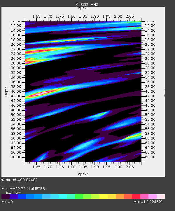
| Estimated Moho Depth: |
40.75 km |
| Estimated Crust Vp/Vs: |
1.66 |
| Assumed Crust Vp: |
6.048 km/s |
| Estimated Crust Vs: |
3.632 km/s |
| Estimated Crust Poisson's Ratio: |
0.22 |
|
| Radial Match: |
90.84482 % |
| Radial Bump: |
400 |
| Transverse Match: |
89.55218 % |
| Transverse Bump: |
400 |
| SOD ConfigId: |
13570011 |
| Insert Time: |
2019-04-28 10:01:14.717 +0000 |
| GWidth: |
2.5 |
| Max Bumps: |
400 |
| Tol: |
0.001 |
|

Signal To Noise
| Channel | StoN | STA | LTA |
| CI:SCI2: :HHZ:20170717T23:43:07.598022Z | 2.6195703 | 2.660218E-6 | 1.0155169E-6 |
| CI:SCI2: :HHN:20170717T23:43:07.598022Z | 1.0760026 | 5.5692414E-7 | 5.175862E-7 |
| CI:SCI2: :HHE:20170717T23:43:07.598022Z | 1.1916949 | 4.788385E-7 | 4.0181303E-7 |
| Arrivals |
| Ps | 4.7 SECOND |
| PpPs | 17 SECOND |
| PsPs/PpSs | 22 SECOND |


