You are here: Home > Network List > TA - USArray Transportable Network (new EarthScope stations) Stations List
> Station J28A Allard Ranch, Norris, SD, USA > Earthquake Result Viewer
J28A Allard Ranch, Norris, SD, USA - Earthquake Result Viewer
| Earthquake location: |
Hokkaido, Japan Region |
| Earthquake latitude/longitude: |
41.8/143.4 |
| Earthquake time(UTC): |
2009/06/05 (156) 03:30:33 GMT |
| Earthquake Depth: |
29 km |
| Earthquake Magnitude: |
6.0 MB, 6.3 MS, 6.4 MW, 6.4 MW |
| Earthquake Catalog/Contributor: |
WHDF/NEIC |
|
| Network: |
TA USArray Transportable Network (new EarthScope stations) |
| Station: |
J28A Allard Ranch, Norris, SD, USA |
| Lat/Lon: |
43.42 N/101.24 W |
| Elevation: |
835 m |
|
| Distance: |
77.2 deg |
| Az: |
42.492 deg |
| Baz: |
316.137 deg |
| Ray Param: |
0.05047038 |
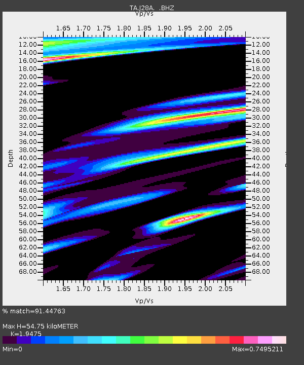
| Estimated Moho Depth: |
54.75 km |
| Estimated Crust Vp/Vs: |
1.95 |
| Assumed Crust Vp: |
6.483 km/s |
| Estimated Crust Vs: |
3.329 km/s |
| Estimated Crust Poisson's Ratio: |
0.32 |
|
| Radial Match: |
91.44763 % |
| Radial Bump: |
312 |
| Transverse Match: |
81.347275 % |
| Transverse Bump: |
358 |
| SOD ConfigId: |
2648 |
| Insert Time: |
2010-03-06 01:59:49.877 +0000 |
| GWidth: |
2.5 |
| Max Bumps: |
400 |
| Tol: |
0.001 |
|

Signal To Noise
| Channel | StoN | STA | LTA |
| TA:J28A: :BHZ:20090605T03:41:52.849001Z | 21.46615 | 1.4575223E-6 | 6.789863E-8 |
| TA:J28A: :BHN:20090605T03:41:52.849001Z | 3.2824895 | 4.1787115E-7 | 1.2730312E-7 |
| TA:J28A: :BHE:20090605T03:41:52.849001Z | 3.6293452 | 3.3423052E-7 | 9.2091135E-8 |
| Arrivals |
| Ps | 8.2 SECOND |
| PpPs | 24 SECOND |
| PsPs/PpSs | 32 SECOND |


