You are here: Home > Network List > HV - Hawaiian Volcano Observatory Network Stations List
> Station MOKD Mokuaweoweo, Hawaii Digital > Earthquake Result Viewer
MOKD Mokuaweoweo, Hawaii Digital - Earthquake Result Viewer
| Earthquake location: |
Komandorskiye Ostrova Region |
| Earthquake latitude/longitude: |
54.2/169.2 |
| Earthquake time(UTC): |
2017/07/17 (198) 23:34:21 GMT |
| Earthquake Depth: |
48 km |
| Earthquake Magnitude: |
7.4 Mi |
| Earthquake Catalog/Contributor: |
NEIC PDE/pt |
|
| Network: |
HV Hawaiian Volcano Observatory Network |
| Station: |
MOKD Mokuaweoweo, Hawaii Digital |
| Lat/Lon: |
19.49 N/155.60 W |
| Elevation: |
4102 m |
|
| Distance: |
43.8 deg |
| Az: |
128.266 deg |
| Baz: |
330.727 deg |
| Ray Param: |
0.072159216 |
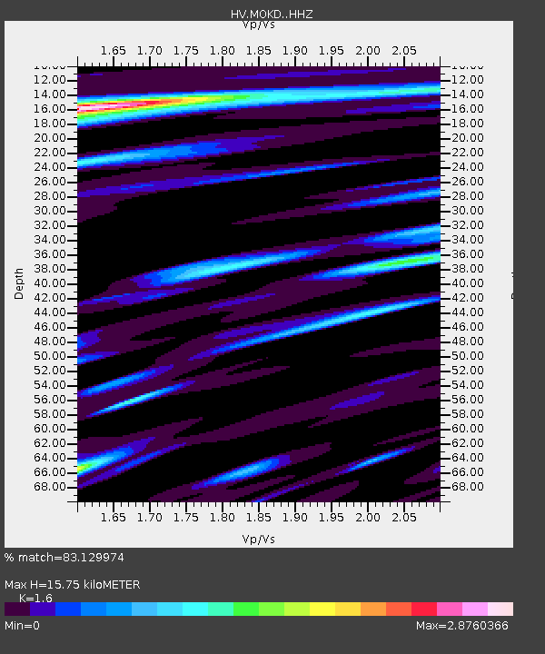
| Estimated Moho Depth: |
15.75 km |
| Estimated Crust Vp/Vs: |
1.60 |
| Assumed Crust Vp: |
5.195 km/s |
| Estimated Crust Vs: |
3.247 km/s |
| Estimated Crust Poisson's Ratio: |
0.18 |
|
| Radial Match: |
83.129974 % |
| Radial Bump: |
400 |
| Transverse Match: |
60.293285 % |
| Transverse Bump: |
400 |
| SOD ConfigId: |
13570011 |
| Insert Time: |
2019-04-28 10:03:10.227 +0000 |
| GWidth: |
2.5 |
| Max Bumps: |
400 |
| Tol: |
0.001 |
|

Signal To Noise
| Channel | StoN | STA | LTA |
| HV:MOKD: :HHZ:20170717T23:41:51.80899Z | 3.158479 | 2.8778097E-6 | 9.111379E-7 |
| HV:MOKD: :HHN:20170717T23:41:51.80899Z | 0.8209366 | 1.5441121E-6 | 1.8809153E-6 |
| HV:MOKD: :HHE:20170717T23:41:51.80899Z | 1.0926582 | 2.701242E-6 | 2.4721749E-6 |
| Arrivals |
| Ps | 1.9 SECOND |
| PpPs | 7.5 SECOND |
| PsPs/PpSs | 9.4 SECOND |


