You are here: Home > Network List > TA - USArray Transportable Network (new EarthScope stations) Stations List
> Station K28A Ten Mile Ranch, Cody, NE, USA > Earthquake Result Viewer
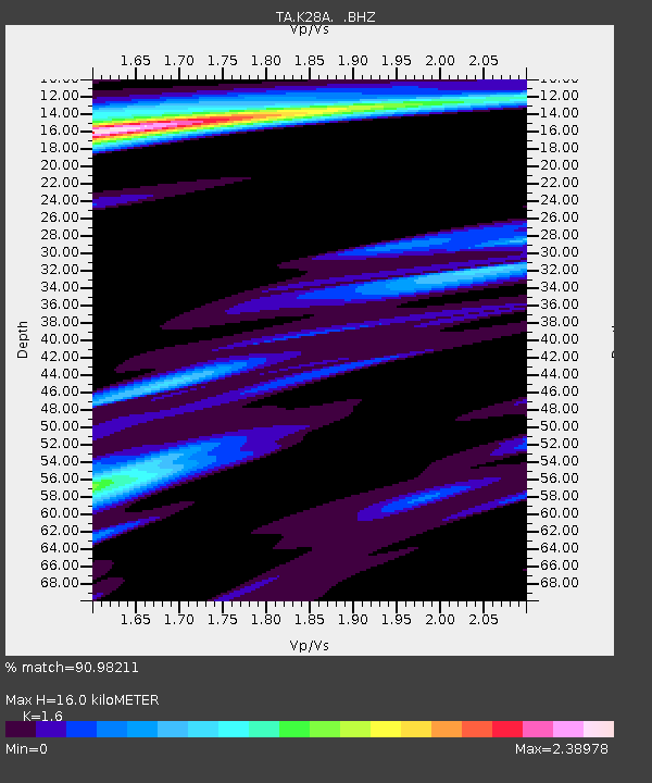
K28A Ten Mile Ranch, Cody, NE, USA - Earthquake Result Viewer
| Earthquake location: |
Norwegian Sea |
| Earthquake latitude/longitude: |
72.2/0.9 |
| Earthquake time(UTC): |
2009/08/20 (232) 06:35:04 GMT |
| Earthquake Depth: |
6.0 km |
| Earthquake Magnitude: |
5.9 MB, 5.7 MS, 6.0 MW, 6.0 MW |
| Earthquake Catalog/Contributor: |
WHDF/NEIC |
|
| Network: |
TA USArray Transportable Network (new EarthScope stations) |
| Station: |
K28A Ten Mile Ranch, Cody, NE, USA |
| Lat/Lon: |
42.71 N/101.37 W |
| Elevation: |
986 m |
|
| Distance: |
53.5 deg |
| Az: |
296.397 deg |
| Baz: |
21.95 deg |
| Ray Param: |
0.06606645 |
| Estimated Moho Depth: |
16.0 km |
| Estimated Crust Vp/Vs: |
1.60 |
| Assumed Crust Vp: |
6.483 km/s |
| Estimated Crust Vs: |
4.052 km/s |
| Estimated Crust Poisson's Ratio: |
0.18 |
|
| Radial Match: |
90.98211 % |
| Radial Bump: |
383 |
| Transverse Match: |
71.11931 % |
| Transverse Bump: |
400 |
| SOD ConfigId: |
2622 |
| Insert Time: |
2010-03-06 02:00:53.032 +0000 |
| GWidth: |
2.5 |
| Max Bumps: |
400 |
| Tol: |
0.001 |
|

Signal To Noise
| Channel | StoN | STA | LTA |
| TA:K28A: :BHZ:20090820T06:43:54.57502Z | 18.438578 | 1.782285E-6 | 9.666066E-8 |
| TA:K28A: :BHN:20090820T06:43:54.57502Z | 2.1640375 | 6.143112E-7 | 2.8387274E-7 |
| TA:K28A: :BHE:20090820T06:43:54.57502Z | 1.0994037 | 4.4443584E-7 | 4.0425172E-7 |
| Arrivals |
| Ps | 1.6 SECOND |
| PpPs | 6.0 SECOND |
| PsPs/PpSs | 7.6 SECOND |


