You are here: Home > Network List > TA - USArray Transportable Network (new EarthScope stations) Stations List
> Station K28A Ten Mile Ranch, Cody, NE, USA > Earthquake Result Viewer
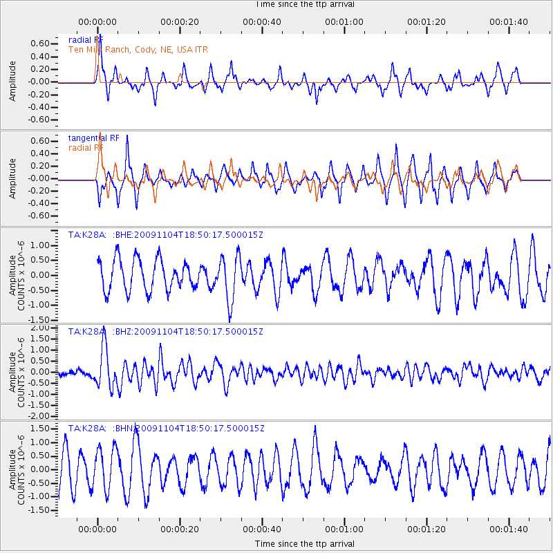
K28A Ten Mile Ranch, Cody, NE, USA - Earthquake Result Viewer
*The percent match for this event was below the threshold and hence no stack was calculated.
| Earthquake location: |
Azores Islands Region |
| Earthquake latitude/longitude: |
36.2/-33.9 |
| Earthquake time(UTC): |
2009/11/04 (308) 18:41:44 GMT |
| Earthquake Depth: |
10 km |
| Earthquake Magnitude: |
5.7 MB, 5.6 MS, 5.9 MW, 5.8 MW |
| Earthquake Catalog/Contributor: |
WHDF/NEIC |
|
| Network: |
TA USArray Transportable Network (new EarthScope stations) |
| Station: |
K28A Ten Mile Ranch, Cody, NE, USA |
| Lat/Lon: |
42.71 N/101.37 W |
| Elevation: |
986 m |
|
| Distance: |
51.3 deg |
| Az: |
299.248 deg |
| Baz: |
73.356 deg |
| Ray Param: |
$rayparam |
*The percent match for this event was below the threshold and hence was not used in the summary stack. |
|
| Radial Match: |
66.67251 % |
| Radial Bump: |
314 |
| Transverse Match: |
65.77034 % |
| Transverse Bump: |
321 |
| SOD ConfigId: |
2622 |
| Insert Time: |
2010-03-06 02:01:33.627 +0000 |
| GWidth: |
2.5 |
| Max Bumps: |
400 |
| Tol: |
0.001 |
|
Signal To Noise
| Channel | StoN | STA | LTA |
| TA:K28A: :BHZ:20091104T18:50:17.500015Z | 6.7721715 | 9.275477E-7 | 1.3696459E-7 |
| TA:K28A: :BHN:20091104T18:50:17.500015Z | 1.1079082 | 7.7672604E-7 | 7.010744E-7 |
| TA:K28A: :BHE:20091104T18:50:17.500015Z | 1.5165935 | 7.72039E-7 | 5.090613E-7 |
| Arrivals |
| Ps | |
| PpPs | |
| PsPs/PpSs | |


