You are here: Home > Network List > TA - USArray Transportable Network (new EarthScope stations) Stations List
> Station L29A Maesberg Ranch, Thedford, NE, USA > Earthquake Result Viewer
L29A Maesberg Ranch, Thedford, NE, USA - Earthquake Result Viewer
| Earthquake location: |
Southeast Of Honshu, Japan |
| Earthquake latitude/longitude: |
32.8/140.4 |
| Earthquake time(UTC): |
2009/08/12 (224) 22:48:51 GMT |
| Earthquake Depth: |
53 km |
| Earthquake Magnitude: |
6.2 MB, 6.6 MW, 6.6 MW |
| Earthquake Catalog/Contributor: |
WHDF/NEIC |
|
| Network: |
TA USArray Transportable Network (new EarthScope stations) |
| Station: |
L29A Maesberg Ranch, Thedford, NE, USA |
| Lat/Lon: |
42.06 N/100.48 W |
| Elevation: |
901 m |
|
| Distance: |
86.9 deg |
| Az: |
40.651 deg |
| Baz: |
312.553 deg |
| Ray Param: |
0.043656312 |
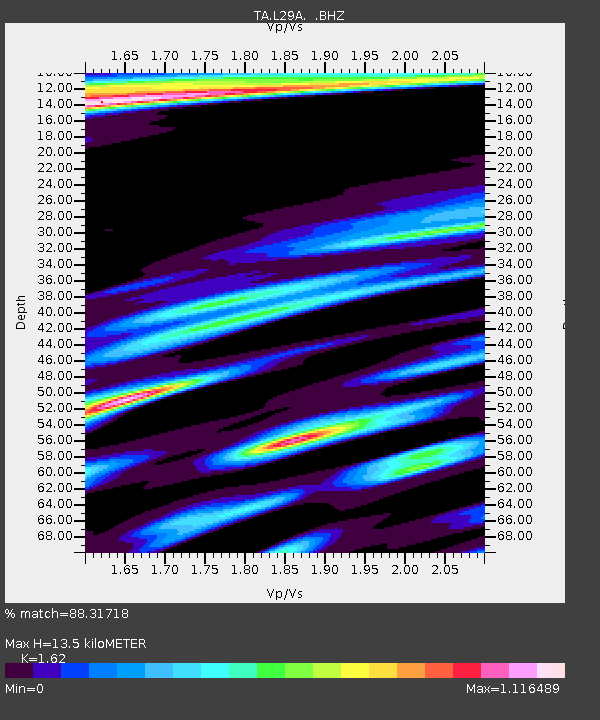
| Estimated Moho Depth: |
13.5 km |
| Estimated Crust Vp/Vs: |
1.62 |
| Assumed Crust Vp: |
6.483 km/s |
| Estimated Crust Vs: |
4.002 km/s |
| Estimated Crust Poisson's Ratio: |
0.19 |
|
| Radial Match: |
88.31718 % |
| Radial Bump: |
400 |
| Transverse Match: |
77.6201 % |
| Transverse Bump: |
399 |
| SOD ConfigId: |
2622 |
| Insert Time: |
2010-03-06 02:01:51.829 +0000 |
| GWidth: |
2.5 |
| Max Bumps: |
400 |
| Tol: |
0.001 |
|
Signal To Noise
| Channel | StoN | STA | LTA |
| TA:L29A: :BHZ:20090812T23:00:59.099016Z | 21.792303 | 2.4154288E-6 | 1.1083861E-7 |
| TA:L29A: :BHN:20090812T23:00:59.099016Z | 3.2399776 | 7.832874E-7 | 2.4175705E-7 |
| TA:L29A: :BHE:20090812T23:00:59.099016Z | 4.9077306 | 9.4951224E-7 | 1.9347276E-7 |
| Arrivals |
| Ps | 1.3 SECOND |
| PpPs | 5.3 SECOND |
| PsPs/PpSs | 6.6 SECOND |


