You are here: Home > Network List > TA - USArray Transportable Network (new EarthScope stations) Stations List
> Station 121A Cookes Peak, Deming, NM, USA > Earthquake Result Viewer
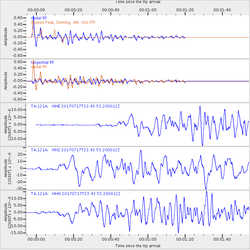
121A Cookes Peak, Deming, NM, USA - Earthquake Result Viewer
*The percent match for this event was below the threshold and hence no stack was calculated.
| Earthquake location: |
Komandorskiye Ostrova Region |
| Earthquake latitude/longitude: |
54.2/169.2 |
| Earthquake time(UTC): |
2017/07/17 (198) 23:34:21 GMT |
| Earthquake Depth: |
48 km |
| Earthquake Magnitude: |
7.4 Mi |
| Earthquake Catalog/Contributor: |
NEIC PDE/pt |
|
| Network: |
TA USArray Transportable Network (new EarthScope stations) |
| Station: |
121A Cookes Peak, Deming, NM, USA |
| Lat/Lon: |
32.53 N/107.79 W |
| Elevation: |
1652 m |
|
| Distance: |
60.4 deg |
| Az: |
74.576 deg |
| Baz: |
317.895 deg |
| Ray Param: |
$rayparam |
*The percent match for this event was below the threshold and hence was not used in the summary stack. |
|
| Radial Match: |
96.31077 % |
| Radial Bump: |
400 |
| Transverse Match: |
88.71823 % |
| Transverse Bump: |
400 |
| SOD ConfigId: |
13570011 |
| Insert Time: |
2019-04-28 10:08:42.750 +0000 |
| GWidth: |
2.5 |
| Max Bumps: |
400 |
| Tol: |
0.001 |
|
Signal To Noise
| Channel | StoN | STA | LTA |
| TA:121A: :HHZ:20170717T23:43:53.200012Z | 11.284058 | 1.32949E-6 | 1.17820214E-7 |
| TA:121A: :HHN:20170717T23:43:53.200012Z | 6.365502 | 5.106585E-7 | 8.022281E-8 |
| TA:121A: :HHE:20170717T23:43:53.200012Z | 6.8433743 | 4.9394635E-7 | 7.217877E-8 |
| Arrivals |
| Ps | |
| PpPs | |
| PsPs/PpSs | |


