You are here: Home > Network List > TA - USArray Transportable Network (new EarthScope stations) Stations List
> Station L29A Maesberg Ranch, Thedford, NE, USA > Earthquake Result Viewer
L29A Maesberg Ranch, Thedford, NE, USA - Earthquake Result Viewer
| Earthquake location: |
Crete, Greece |
| Earthquake latitude/longitude: |
34.2/25.5 |
| Earthquake time(UTC): |
2009/07/01 (182) 09:30:10 GMT |
| Earthquake Depth: |
19 km |
| Earthquake Magnitude: |
6.1 MB, 6.3 MS, 6.4 MW, 6.4 MW |
| Earthquake Catalog/Contributor: |
WHDF/NEIC |
|
| Network: |
TA USArray Transportable Network (new EarthScope stations) |
| Station: |
L29A Maesberg Ranch, Thedford, NE, USA |
| Lat/Lon: |
42.06 N/100.48 W |
| Elevation: |
901 m |
|
| Distance: |
89.4 deg |
| Az: |
322.926 deg |
| Baz: |
42.167 deg |
| Ray Param: |
0.04186983 |
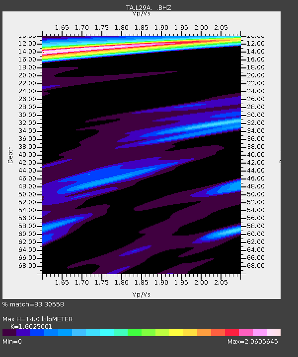
| Estimated Moho Depth: |
14.0 km |
| Estimated Crust Vp/Vs: |
1.60 |
| Assumed Crust Vp: |
6.483 km/s |
| Estimated Crust Vs: |
4.045 km/s |
| Estimated Crust Poisson's Ratio: |
0.18 |
|
| Radial Match: |
83.30558 % |
| Radial Bump: |
368 |
| Transverse Match: |
62.099125 % |
| Transverse Bump: |
385 |
| SOD ConfigId: |
2648 |
| Insert Time: |
2010-03-06 02:02:02.989 +0000 |
| GWidth: |
2.5 |
| Max Bumps: |
400 |
| Tol: |
0.001 |
|

Signal To Noise
| Channel | StoN | STA | LTA |
| TA:L29A: :BHZ:20090701T09:42:34.199001Z | 3.2406988 | 3.985038E-7 | 1.2296849E-7 |
| TA:L29A: :BHN:20090701T09:42:34.199001Z | 0.6940784 | 3.7518757E-7 | 5.40555E-7 |
| TA:L29A: :BHE:20090701T09:42:34.199001Z | 1.0854223 | 5.4216565E-7 | 4.994975E-7 |
| Arrivals |
| Ps | 1.3 SECOND |
| PpPs | 5.5 SECOND |
| PsPs/PpSs | 6.8 SECOND |


