You are here: Home > Network List > TA - USArray Transportable Network (new EarthScope stations) Stations List
> Station R33M Jennings River, BC, CAN > Earthquake Result Viewer
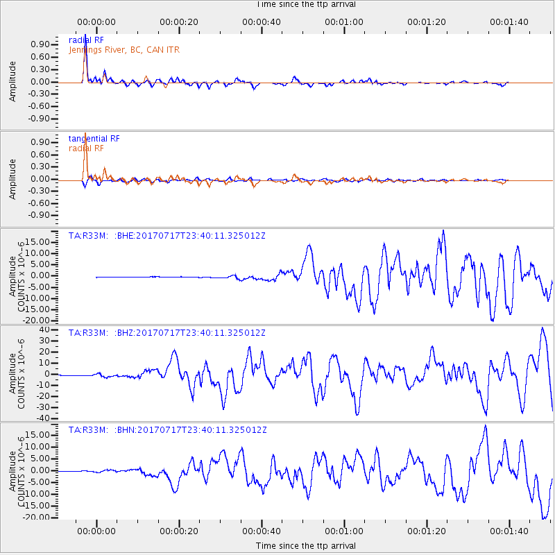
R33M Jennings River, BC, CAN - Earthquake Result Viewer
*The percent match for this event was below the threshold and hence no stack was calculated.
| Earthquake location: |
Komandorskiye Ostrova Region |
| Earthquake latitude/longitude: |
54.2/169.2 |
| Earthquake time(UTC): |
2017/07/17 (198) 23:34:21 GMT |
| Earthquake Depth: |
48 km |
| Earthquake Magnitude: |
7.4 Mi |
| Earthquake Catalog/Contributor: |
NEIC PDE/pt |
|
| Network: |
TA USArray Transportable Network (new EarthScope stations) |
| Station: |
R33M Jennings River, BC, CAN |
| Lat/Lon: |
59.39 N/130.97 W |
| Elevation: |
1437 m |
|
| Distance: |
32.2 deg |
| Az: |
56.145 deg |
| Baz: |
287.519 deg |
| Ray Param: |
$rayparam |
*The percent match for this event was below the threshold and hence was not used in the summary stack. |
|
| Radial Match: |
92.799866 % |
| Radial Bump: |
320 |
| Transverse Match: |
82.27632 % |
| Transverse Bump: |
400 |
| SOD ConfigId: |
13570011 |
| Insert Time: |
2019-04-28 10:09:02.375 +0000 |
| GWidth: |
2.5 |
| Max Bumps: |
400 |
| Tol: |
0.001 |
|
Signal To Noise
| Channel | StoN | STA | LTA |
| TA:R33M: :BHZ:20170717T23:40:11.325012Z | 9.68148 | 1.3820318E-6 | 1.4275004E-7 |
| TA:R33M: :BHN:20170717T23:40:11.325012Z | 7.7609076 | 4.818966E-7 | 6.209282E-8 |
| TA:R33M: :BHE:20170717T23:40:11.325012Z | 10.11256 | 8.535357E-7 | 8.440353E-8 |
| Arrivals |
| Ps | |
| PpPs | |
| PsPs/PpSs | |


