You are here: Home > Network List > IU - Global Seismograph Network (GSN - IRIS/USGS) Stations List
> Station KMBO Kilima Mbogo, Kenya > Earthquake Result Viewer
KMBO Kilima Mbogo, Kenya - Earthquake Result Viewer
| Earthquake location: |
Southwest Indian Ridge |
| Earthquake latitude/longitude: |
-31.3/58.1 |
| Earthquake time(UTC): |
2016/01/12 (012) 09:45:11 GMT |
| Earthquake Depth: |
10 km |
| Earthquake Magnitude: |
5.9 MB |
| Earthquake Catalog/Contributor: |
NEIC PDE/NEIC COMCAT |
|
| Network: |
IU Global Seismograph Network (GSN - IRIS/USGS) |
| Station: |
KMBO Kilima Mbogo, Kenya |
| Lat/Lon: |
1.13 S/37.25 E |
| Elevation: |
1950 m |
|
| Distance: |
35.9 deg |
| Az: |
322.58 deg |
| Baz: |
148.641 deg |
| Ray Param: |
0.076968804 |
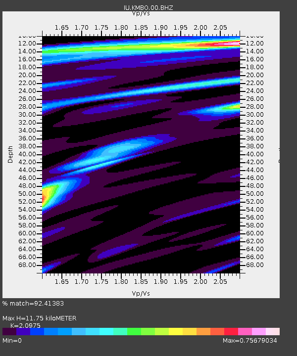
| Estimated Moho Depth: |
11.75 km |
| Estimated Crust Vp/Vs: |
2.10 |
| Assumed Crust Vp: |
6.601 km/s |
| Estimated Crust Vs: |
3.147 km/s |
| Estimated Crust Poisson's Ratio: |
0.35 |
|
| Radial Match: |
92.41383 % |
| Radial Bump: |
216 |
| Transverse Match: |
54.390175 % |
| Transverse Bump: |
400 |
| SOD ConfigId: |
1399611 |
| Insert Time: |
2016-01-26 10:17:00.006 +0000 |
| GWidth: |
2.5 |
| Max Bumps: |
400 |
| Tol: |
0.001 |
|
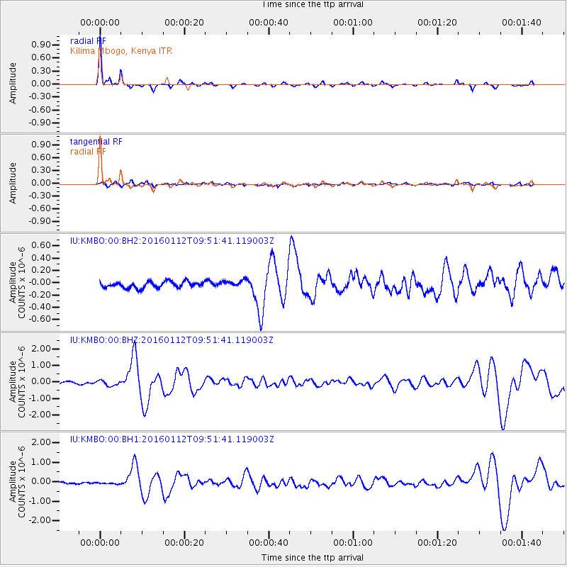
Signal To Noise
| Channel | StoN | STA | LTA |
| IU:KMBO:00:BHZ:20160112T09:51:41.119003Z | 2.1942284 | 1.5965344E-7 | 7.276062E-8 |
| IU:KMBO:00:BH1:20160112T09:51:41.119003Z | 0.79622436 | 2.8631588E-8 | 3.5959197E-8 |
| IU:KMBO:00:BH2:20160112T09:51:41.119003Z | 1.1808357 | 5.935958E-8 | 5.0269122E-8 |
| Arrivals |
| Ps | 2.1 SECOND |
| PpPs | 5.2 SECOND |
| PsPs/PpSs | 7.2 SECOND |


