You are here: Home > Network List > TA - USArray Transportable Network (new EarthScope stations) Stations List
> Station V35K Ketchikan, AK, USA > Earthquake Result Viewer
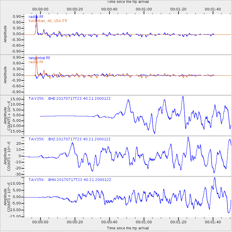
V35K Ketchikan, AK, USA - Earthquake Result Viewer
*The percent match for this event was below the threshold and hence no stack was calculated.
| Earthquake location: |
Komandorskiye Ostrova Region |
| Earthquake latitude/longitude: |
54.2/169.2 |
| Earthquake time(UTC): |
2017/07/17 (198) 23:34:21 GMT |
| Earthquake Depth: |
48 km |
| Earthquake Magnitude: |
7.4 Mi |
| Earthquake Catalog/Contributor: |
NEIC PDE/pt |
|
| Network: |
TA USArray Transportable Network (new EarthScope stations) |
| Station: |
V35K Ketchikan, AK, USA |
| Lat/Lon: |
55.33 N/131.62 W |
| Elevation: |
64 m |
|
| Distance: |
33.3 deg |
| Az: |
63.447 deg |
| Baz: |
293.12 deg |
| Ray Param: |
$rayparam |
*The percent match for this event was below the threshold and hence was not used in the summary stack. |
|
| Radial Match: |
92.19804 % |
| Radial Bump: |
265 |
| Transverse Match: |
79.48208 % |
| Transverse Bump: |
400 |
| SOD ConfigId: |
13570011 |
| Insert Time: |
2019-04-28 10:09:11.717 +0000 |
| GWidth: |
2.5 |
| Max Bumps: |
400 |
| Tol: |
0.001 |
|
Signal To Noise
| Channel | StoN | STA | LTA |
| TA:V35K: :BHZ:20170717T23:40:21.200012Z | 7.3755383 | 1.4561037E-6 | 1.9742338E-7 |
| TA:V35K: :BHN:20170717T23:40:21.200012Z | 4.4754677 | 2.543916E-7 | 5.6841344E-8 |
| TA:V35K: :BHE:20170717T23:40:21.200012Z | 8.571343 | 9.069151E-7 | 1.05807814E-7 |
| Arrivals |
| Ps | |
| PpPs | |
| PsPs/PpSs | |


